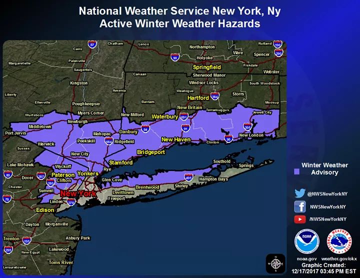
Winter Weather Advisory, Tonight, Dec 17, and morning rush


The NWS has ended the Winter Weather Advisory for our area this morning. There was very little precipitation and temps are now above freezing. There may still be slick spots, so be careful out there.
Dec 18, 2017 at 7:25am Edited
Thanks, Max! From our own quick super-local check, our steps are slick, but the driveway and sidewalk at our house seemed OK.
In order to add a comment – you must Join this community – Click here to do so.


Be aware of the potential for icy conditions during the morning commute tomorrow, Monday 12/17.
From the NWS:
Winter Weather Advisory
URGENT - WINTER WEATHER MESSAGE
National Weather Service New York NY
328 PM EST Sun Dec 17 2017
CTZ005-006-009-010-NJZ002-004-103>107-NYZ067>071-078-079-177-
180430-
/O.NEW.KOKX.WW.Y.0004.171218T0300Z-171218T1200Z/
Northern Fairfield-Northern New Haven-Southern Fairfield-
Southern New Haven-Western Passaic-Eastern Passaic-Western Bergen-
Eastern Bergen-Western Essex-Eastern Essex-Western Union-Orange-
Putnam-Rockland-Northern Westchester-Southern Westchester-
Northwestern Suffolk-Northeastern Suffolk-Northern Nassau-
328 PM EST Sun Dec 17 2017
...WINTER WEATHER ADVISORY IN EFFECT FROM 10 PM THIS EVENING TO
7 AM EST MONDAY...
* WHAT...Light freezing rain expected, including during the
morning commute on Monday. Total accumulations of a trace to a
hundredth of an inch are expected.
* WHERE...Portions of northeast New Jersey, southern Connecticut
and southeast New York.
* WHEN...From 10 PM this evening to 7 AM EST Monday.
* ADDITIONAL DETAILS...The precipitation will likely start as snow
tonight before transitioning to sleet and freezing rain late
tonight and early Monday morning. A few tenths of an inch of
snow and sleet are possible, especially from Connecticut to the
Lower Hudson Valley.
PRECAUTIONARY/PREPAREDNESS ACTIONS...
A Winter Weather Advisory means that periods of snow...sleet...or
freezing rain will cause travel difficulties. Be prepared for
slippery roads and limited visibilities...and use caution while
driving.