Irma -- Updated 9/11

So, may I humbly suggest that you DO NOT POST CHARTS IF YOU DO NOT KNOW WHAT THE **** THEY SAY?!?!
This is serious enough without unnecessarily scaring the crap out of people.
Now that I am done shouting, I will say that the 0600 GFS scared the crap out of me this morning with that track into Philly. I very specifically did not post it, though, because I knew it would shift on the next run and did not want to freak people out.

max_weisenfeld said:
So, may I humbly suggest that you DO NOT POST CHARTS IF YOU DO NOT KNOW WHAT THE **** THEY SAY?!?!
This is serious enough without unnecessarily scaring the crap out of people.
True, being long range models, they can be alarming.
But you really think people on MOL are simple or nervous enough to be seriously scared? 
Having explained long range charts leave something to be desired, I would still think the more info the better.
If there is a chance we can be hit, its better to prepare this weekend than wait until 5 days before when everyone else (if need be) is running to the stores. It doesn't hurt to buy things such as batteries or bottled water now, perishables that last for years.
Yes, your above chart does show a miss. Some do, some don't.
But, after this, I will refrain from showing more. Those who do want it can go and look directly.


BG9, Given years of reading Max's posts and trusting his predictions over all the TV people.
I'd defer. The man is amazing. His advice and timing is very helpful to this Essex County resident!
And Most Appreciated!
Of course you are "right" about being prepped but...
Best Regards,
Ron Carter
BG9 said:
max_weisenfeld said:
So, may I humbly suggest that you DO NOT POST CHARTS IF YOU DO NOT KNOW WHAT THE **** THEY SAY?!?!
This is serious enough without unnecessarily scaring the crap out of people.
True, being long range models, they can be alarming.
But you really think people on MOL are simple or nervous enough to be seriously scared?
Having explained long range charts leave something to be desired, I would still think the more info the better.
If there is a chance we can be hit, its better to prepare this weekend than wait until 5 days before when everyone else (if need be) is running to the stores. It doesn't hurt to buy things such as batteries or bottled water now, perishables that last for years.
Yes, your above chart does show a miss. Some do, some don't.
But, after this, I will refrain from showing more. Those who do want it can go and look directly.
There is a wide variety of people on here, and that was a particularly and unnecessarily alarming image.
This evening, there is still a fair amount of uncertainty in the forecast track for Irma beyond the next three days. At this time, it is a small storm and (for a hurricane) not particularly intense. The conditions over the next 72 hours are not conducive to major development, and no landfall is immanent.
Days 3 - 5 are a mixed bag, with conditions favoring a wider variety of interpretations. What is most likely is that the storm would begin to develop more rapidly and head towards the Lesser Antilles islands, but conditions also exist that could continue to dampen the storm's growth.
For days 5 - 10, the National Hurricane Center says:
It is much too early to determine what direct impacts Irma will
have on the Bahamas and the continental United States.  Regardless,
everyone in hurricane-prone areas should ensure that they have their
hurricane plan in place, as we are now near the peak of the season.
As you have seen from our dueling charts posts above, there are wide swings from model run to model run for everything beyond Tuesday. Basic prudence says @BG9 is right in that the, while not milk and eggs time, this would be a good time to make sure your sump pump works, to make sure you have batteries, and that you have water. for further preparedness, there are some good resources here: http://www.nws.noaa.gov/om/hurricane/index.shtml
Another point to bear in mind is that Harvey recovery is using FEMA and other resources to capacity, and if there were to be a strike here, which is still quite unlikely from Irma but within possibility, we would be quite on our own.
I should probably add that the scary model runs are showing landfalls south of MAPSO, not direct hits on us. Even the one I yelled at BG9 about shows a Delaware Bay landfall. Other scary runs have swung from Georgia to the most recent GFS which has the consensus line running up the Chesapeake. But there are just as many runs showing Irma not making landfall at all, and there are several moving parts which are still very much outside of any reasonable forecast range.

I'm not worried about us getting hit here, but if Puerto Rico gets hit bad then my husband has a pretty good chance of being sent there for the rescue efforts.

Don't live run to run. Trust me. Also many of the GFS solutions have been unphysical and really tenuous given that it's a global model. We're also at a point where intensify errors will feedback onto track errors. Spend more time looking at ensembles than deterministic models.
No. Many if not most Atlantic hurricanes form where Irma formed. Nothing anomalous.
drummerboy said:
I thought I read somewhere that Irma has started further east than any other storm.
Is that correct, and if so, wouldn't that make it at least a bit of an "anomalous" storm?
That forecast is useless. It is fantasyland.
max_weisenfeld said:
BG9 said:
max_weisenfeld said:
So, may I humbly suggest that you DO NOT POST CHARTS IF YOU DO NOT KNOW WHAT THE **** THEY SAY?!?!
This is serious enough without unnecessarily scaring the crap out of people.
True, being long range models, they can be alarming.
But you really think people on MOL are simple or nervous enough to be seriously scared?
Having explained long range charts leave something to be desired, I would still think the more info the better.
If there is a chance we can be hit, its better to prepare this weekend than wait until 5 days before when everyone else (if need be) is running to the stores. It doesn't hurt to buy things such as batteries or bottled water now, perishables that last for years.
Yes, your above chart does show a miss. Some do, some don't.
But, after this, I will refrain from showing more. Those who do want it can go and look directly.
There is a wide variety of people on here, and that was a particularly and unnecessarily alarming image.
I'm an amateur, but I don't see how that Atlantic ridge can swing it that far inland the way the means, both GFS and Euro, are trending, which is why I keep trying to tamp things down. What worries me is that the TV guys are going to start hyping this based on the means, and given that I barely understand what I am looking at with the ensembles, asking the average person in the street to do so is unrealistic.
Until the GFS can figure out what's going on with ET transition of the TC over the pacific, and how that's going to feedback onto the large scale, I wouldn't lend much credence to its solution. The track of this depends heavily on that. Plus, given how the dynamics of chaos work, any intensity forecast you see is really a shot in the dark this far out. Any observation errors are going to heavily influence the entire forecast.
max_weisenfeld said:
I'm an amateur, but I don't see how that Atlantic ridge can swing it that far inland the way the means, both GFS and Euro, are trending, which is why I keep trying to tamp things down. What worries me is that the TV guys are going to start hyping this based on the means, and given that I barely understand what I am looking at with the ensembles, asking the average person in the street to do so is unrealistic.
I still think that literally any spot along the eastern seaboard is in play, and given some of the maximum potential intensity forecasts, a major is possible too. But still way too early to take this for gospel.
http://wxmaps.org/pix/hurpot.html
WxNut2.0 said:
That forecast is useless. It is fantasyland.
max_weisenfeld said:
BG9 said:
max_weisenfeld said:
So, may I humbly suggest that you DO NOT POST CHARTS IF YOU DO NOT KNOW WHAT THE **** THEY SAY?!?!
This is serious enough without unnecessarily scaring the crap out of people.
True, being long range models, they can be alarming.
But you really think people on MOL are simple or nervous enough to be seriously scared?
Having explained long range charts leave something to be desired, I would still think the more info the better.
If there is a chance we can be hit, its better to prepare this weekend than wait until 5 days before when everyone else (if need be) is running to the stores. It doesn't hurt to buy things such as batteries or bottled water now, perishables that last for years.
Yes, your above chart does show a miss. Some do, some don't.
But, after this, I will refrain from showing more. Those who do want it can go and look directly.
There is a wide variety of people on here, and that was a particularly and unnecessarily alarming image.
Really? Fantasy? Yet, tracks are built from computer models created by professionals for use by the "trade."
The "fantasy" forecast tracks were from the following models:
AC00 GFS Ensemble Control Forecast
AEMN GFS Ensemble Mean Forecast
AVNO Global Forecast System Model Forecast
CTCX Experimental U.S. Navy COAMPS-TC Model Forecast
HMON Hurricanes in a Multiscale Ocean-Coupled Non-Hydrostatic Forecast
HWRF HWRF Hurricane Model Forecast Track/Intensity
NVGM U.S. Navy NAVGEM Model Forecast
Thanks. Care to explain how any of those models generate the tracks? You seem like an expert here. What are the differences in those models? Do you know? Two of them are the same. Wanna guess which?
Model forecasts a week out for intensity and track are useless.
BG9 said:
WxNut2.0 said:
That forecast is useless. It is fantasyland.
max_weisenfeld said:
BG9 said:
max_weisenfeld said:
So, may I humbly suggest that you DO NOT POST CHARTS IF YOU DO NOT KNOW WHAT THE **** THEY SAY?!?!
This is serious enough without unnecessarily scaring the crap out of people.
True, being long range models, they can be alarming.
But you really think people on MOL are simple or nervous enough to be seriously scared?
Having explained long range charts leave something to be desired, I would still think the more info the better.
If there is a chance we can be hit, its better to prepare this weekend than wait until 5 days before when everyone else (if need be) is running to the stores. It doesn't hurt to buy things such as batteries or bottled water now, perishables that last for years.
Yes, your above chart does show a miss. Some do, some don't.
But, after this, I will refrain from showing more. Those who do want it can go and look directly.
There is a wide variety of people on here, and that was a particularly and unnecessarily alarming image.
Really? Fantasy? Yet, tracks are built from computer models created by professionals for use by the "trade."
The "fantasy" forecast tracks were from the following models:
AC00 GFS Ensemble Control Forecast
AEMN GFS Ensemble Mean Forecast
AVNO Global Forecast System Model Forecast
CTCX Experimental U.S. Navy COAMPS-TC Model Forecast
HMON Hurricanes in a Multiscale Ocean-Coupled Non-Hydrostatic Forecast
HWRF HWRF Hurricane Model Forecast Track/Intensity
NVGM U.S. Navy NAVGEM Model Forecast
it's one thing to post about what you don't know when it's opinion. But posting raw model output plots when you don't understand them in this context adds to hysteria and misinformation
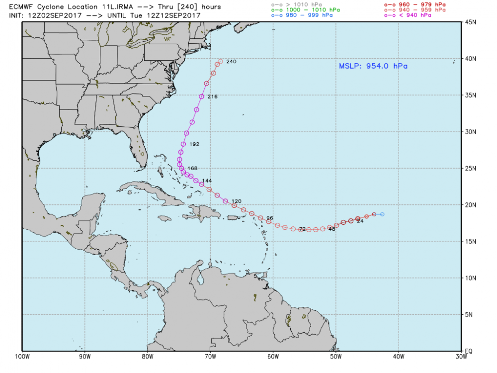
Here's another way to look at the issue WxNut2.0 is pointing out. The AEMN model you mention above, the GFS mean, is simple the average, the mean, of the GFS ensemble, which is the actual output of the GFS, and looks like this:
Without looking at the underlying atmospheric movements, you have no way of knowing which of those lines is more likely than any others. Neither does the model, which after all is nothing more than a very very complicated math problem. So the computer draws a line through the average of all those other lines, like this (the GFS is the bright red line labeled AEMN):
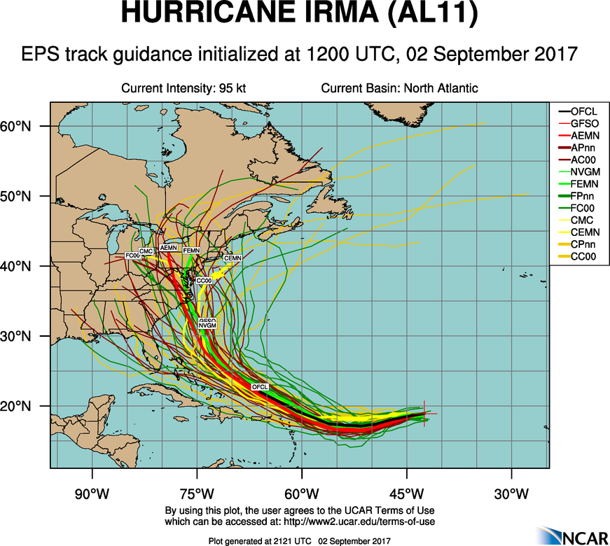
That bright red line, the one arbitrarily calculated from all the others, is the only output from the GFS on the chart you posted, but is is not much more valid than any of the others.
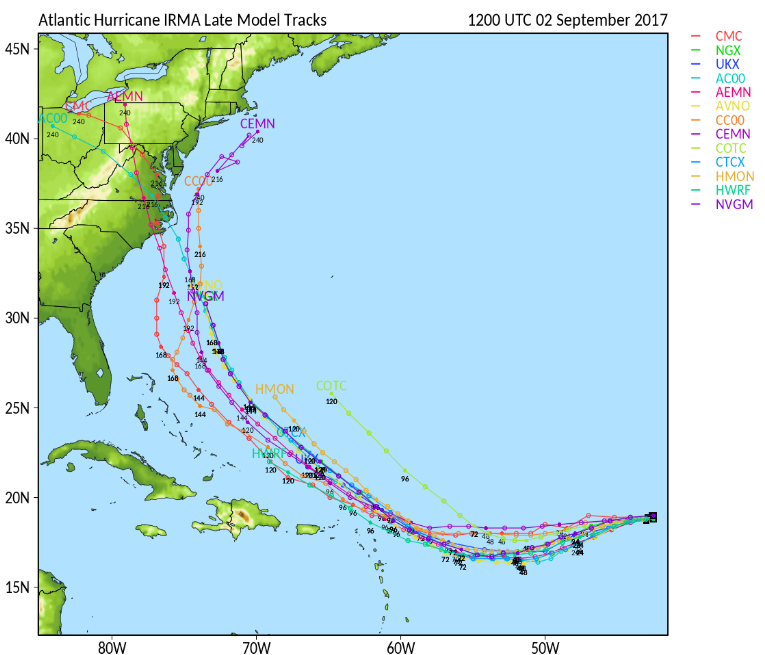
when we are in a closer time range, when the outputs are more closely clustered, then a consensus can be extrapolated from the lines, like in the first three days of this chart, where we can have a fairly clear consensus of where the storm is headed:
But even there, I would be concerned about the spread at 96 hours, and be looking at the components. the real forecasters would be looking at all the things that are influencing the output, too, like the ridge over the north Atlantic or the trough that just made landfall in California ahead of the Pacific Typhoon. These don't show up on these charts but experienced meteorologists can look at them and understand how they might be influencing not only the weather but the data in ways the purely mathematical approach of the model cannot.
The models are tools, they are not forecasts.
That. But also, we are dealing with highly non-linear simulations of the atmosphere in which any small perturbation will throw the entire forecast off into obvlivion. This is especially true when it comes to tropical systems that are governed almost exclusively by convection. A small error in observations won't create a huge problem 12 hours in. But 168 hours in you better believe that forecast is useless.

As always Max, you are the voice of reason. If you say worry, I worry. Otherwise "not so much" though I always have my emergency supplies, car filled with gas and phone charger charged up just in case. Oh, also plenty of wine on hand.
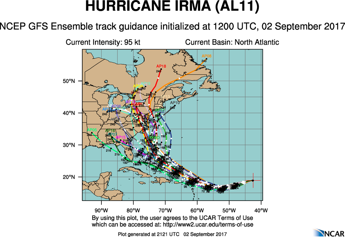
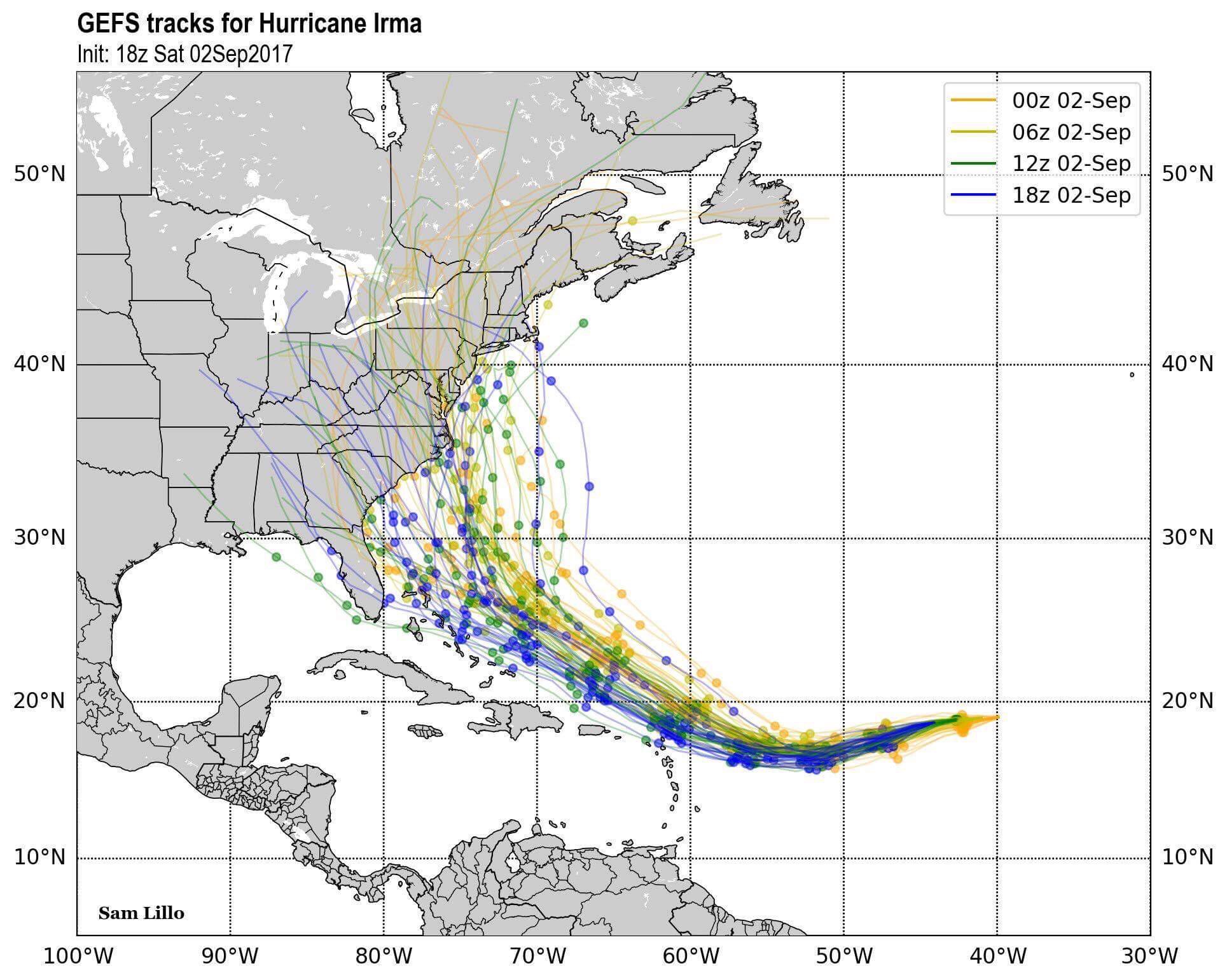
This is why these plots are useless. This is the gfs ensemble for the last four cycles (last four times it was run). Not much consistency in the track. Ensembles are meant to give a general idea of the envelope of predictability. Even the ensemble is all over the place. The normal GFS or any other "deterministic" fcst will be even less certain.


fiche said:
As always Max, you are the voice of reason. If you say worry, I worry. Otherwise "not so much" though I always have my emergency supplies, car filled with gas and phone charger charged up just in case. Oh, also plenty of wine on hand.
I will second that emotion. Asked today what was going to happen with Irma, I said, "Let me check with my local weather weenie." 


In the meantime, the Euro, which was indicating a direct hit on the Carolinas this morning, now shows a complete miss of CONUS: