Irma -- Updated 9/11


My Mom lives in Dominican Rep, they already know they will be getting a lot of rain .. hopefully this hurricane goes north.


HarleyQuinn said:
My Mom lives in Dominican Rep, they already know they will be getting a lot of rain .. hopefully this hurricane goes north.
Just not north toward us!


yahooyahoo said:
Should I stock up on eggs and bread yet?
You forgot the milk. And if you don't have any maple syrup in the house you might want to grab some while you're in the store buying your eggs, milk, and bread to make french toast.

doulamomma said:
@spontaneous - I'm in PR now and they are expecting Irma Th
Thank you. Stay safe there.
Hubby's employer still isn't sure of anything yet, they just keep telling them to be prepared to go if needed.
spontaneous said:
doulamomma said:
@spontaneous - I'm in PR now and they are expecting Irma Th
Thank you. Stay safe there.
Hubby's employer still isn't sure of anything yet, they just keep telling them to be prepared to go if needed.
We are flying back today - hope the storm stays out to sea and your husband doesn't have to go!
@max good news that there are no updates? Hoping this means the reports are trending away from us!

Or maybe he is just enjoying his labor day weekend.
But it does seem as if the models are trending further south putting a hit on Florida more likely.

The models are definitely trending well away from maplewood. But as ska said, south Florida is not in a good spot at the moment. And worse even, it's possible this thing goes into the gulf, putting Houston in play. Again, I should stress that things are still very subject to change.
doulamomma said:
@max good news that there are no updates? Hoping this means the reports are trending away from us!

WxNut2.0 said:
The models are definitely trending well away from maplewood. But as ska said, south Florida is not in a good spot at the moment. And worse even, it's possible this thing goes into the gulf, putting Houston in play. Again, I should stress that things are still very subject to change.
doulamomma said:
@max good news that there are no updates? Hoping this means the reports are trending away from us!
Understood. Hoping it misses everyone

Irma Update for Labor Day
The short answer is that it is much less likely that hurricane Irma will head up the east coast with this morning's analysis. Unfortunately, it is even less likely that the storm wil head out to sea and not make landfall in the continental USA.
The long version:
We have much more data now than we did a few days ago. NOAA has flown several missions into the storm to gather data, and a particular feature from the Pacific Northwest is now onshore and well-sampled, giving insight into how it could affect the storm track.
All that said, any forecast track farther out than five (5) days is still very very speculative. The spread in the models from 120 hours onward is hundreds if not a thousand miles wide. The shift in model track from the last three days has been over 1,000 miles of coastline, from Philadelphia to Florida.
Over the last several days, hurricane Irma has strengthened a bit and grown larger, moving slowly to the west. A strong high pressure ridge in the North Atlantic has kept its course to the west as it bears down on the Lesser Antilles islands.
Beyond 5 days, the storm will clear the ridge and could head more northwards. Where, when, and how sharply this turn to the north occurs is the $64 billion question.
Irma is and will remain for the next several days a major Atlantic Hurricane and should not make landfall for the next 24 - 36 hours. As of this morning, there are hurricane warnings up for both the windward and leeward islands including Antigua, St Martins, and Martinique. A hurricane watch is in effect for the Virgin Islands and Puerto Rico.
If the storm turns north as modeled, the most likely landfall would be in Florida. The entire state is under threat at this time for a major hit, possibly Friday or Saturday the 8th and 9th. This is still highly speculative as a small deviation in the storm track if and when the storm turns would have larger implications three days later on the final landfall.
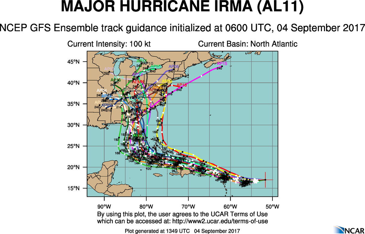
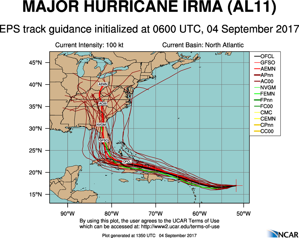
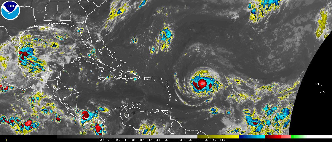
I have attached three images with this post.
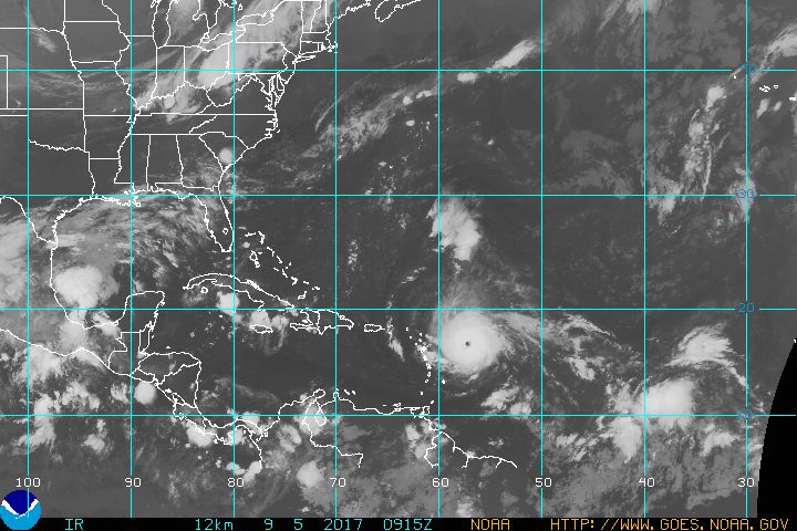
The first is an infrared enhanced satellite image showing Irma in red, and to Irma's right and slightly below, a group of disorganized storms in blue currently know as invest low AL94 but possibly to become tropical storm Jose.
The second is the Euro 'Spaghetti' Chart from the 06 uts run this morning showing the spread of possible tracks. This one has moved a bit west from last night's run.
The last is the GFS (American) 'Spaghetti' Chart, showing a similar spread.
These charts are still very volatile, and I am posting them for two purposes. The first is to show how wide the cone of possible solutions is on any given run. Add to that the fact that the cone moves every single run, and you will see why the NHC and others are still urging caution in predicting where landfall might come, while prudent Floridians are starting to test their generators and supplies.
The second reason I post them is that of these three images, the sources of two are threatened with massive budget cuts from the current administration.
Without these tools, hurricanes like Harvey and Irma that kill or could kill dozens in this country would likely kill thousands, just like they did in the days before modern forecasting. If you are not regularly calling your representatives and senators, please do. Make one of those calls in support of NOAA and NASA.

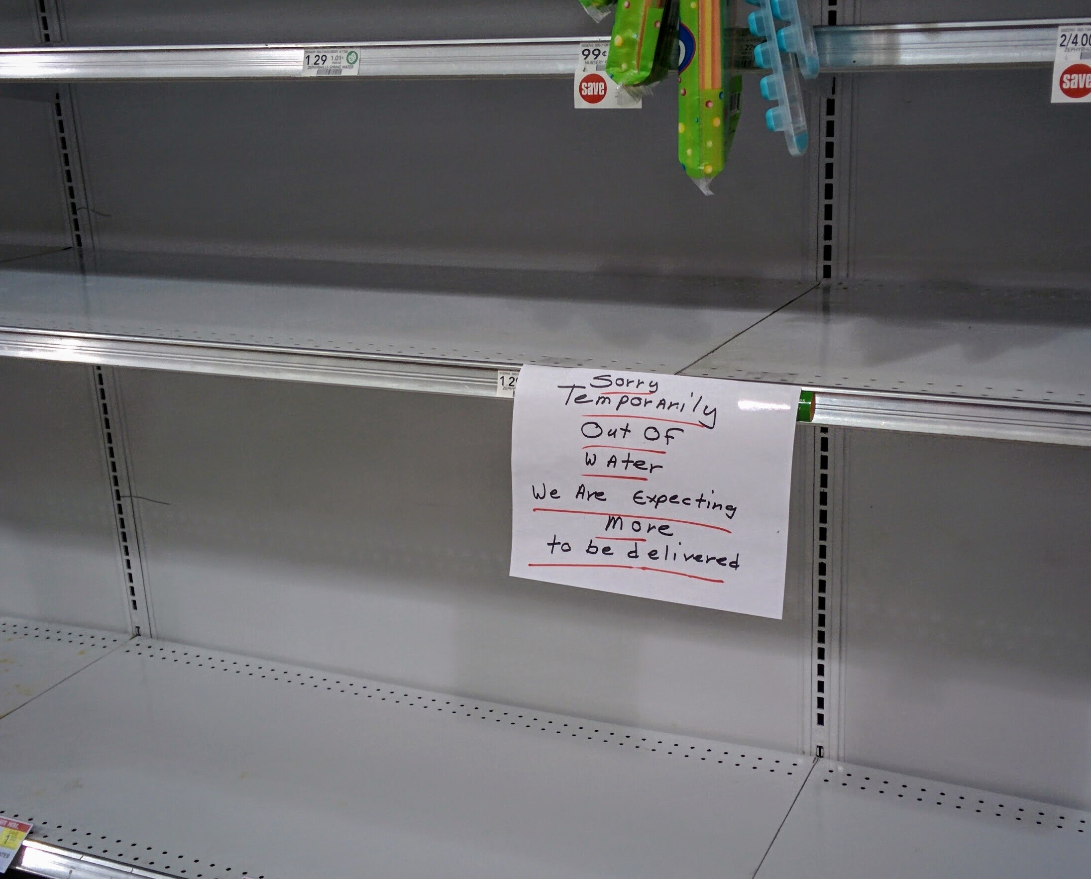
Greetings from South Florida.
Publix is out of water, and very low on milk, eggs, bread.
I miss publix.
ril said:
Greetings from South Florida.
Publix is out of water, and very low on milk, eggs, bread.
Milk bought Sunday or Monday for a possible storm on Friday or Saturday is likely to be wasted.

MAX, Thank you again for your wise prognostications. For years you have gotten us safely through winter and now this. Our retirement home is in St Petersburg so this is of great concern for us. Our house is about 6 blocks from the Coffee Pot Bayou, which is an extension of Tampa Bay, but we are at a 45 ft elevation so we are not too worried about flooding. But I've read how much damage the wind of a CAT 4 and 5 hurricane can do and that is scary. We have our handyman ready to board up our windows if it turns out to be necessary.
Do you have any idea how strong Irma is likely to become. Thanks again.
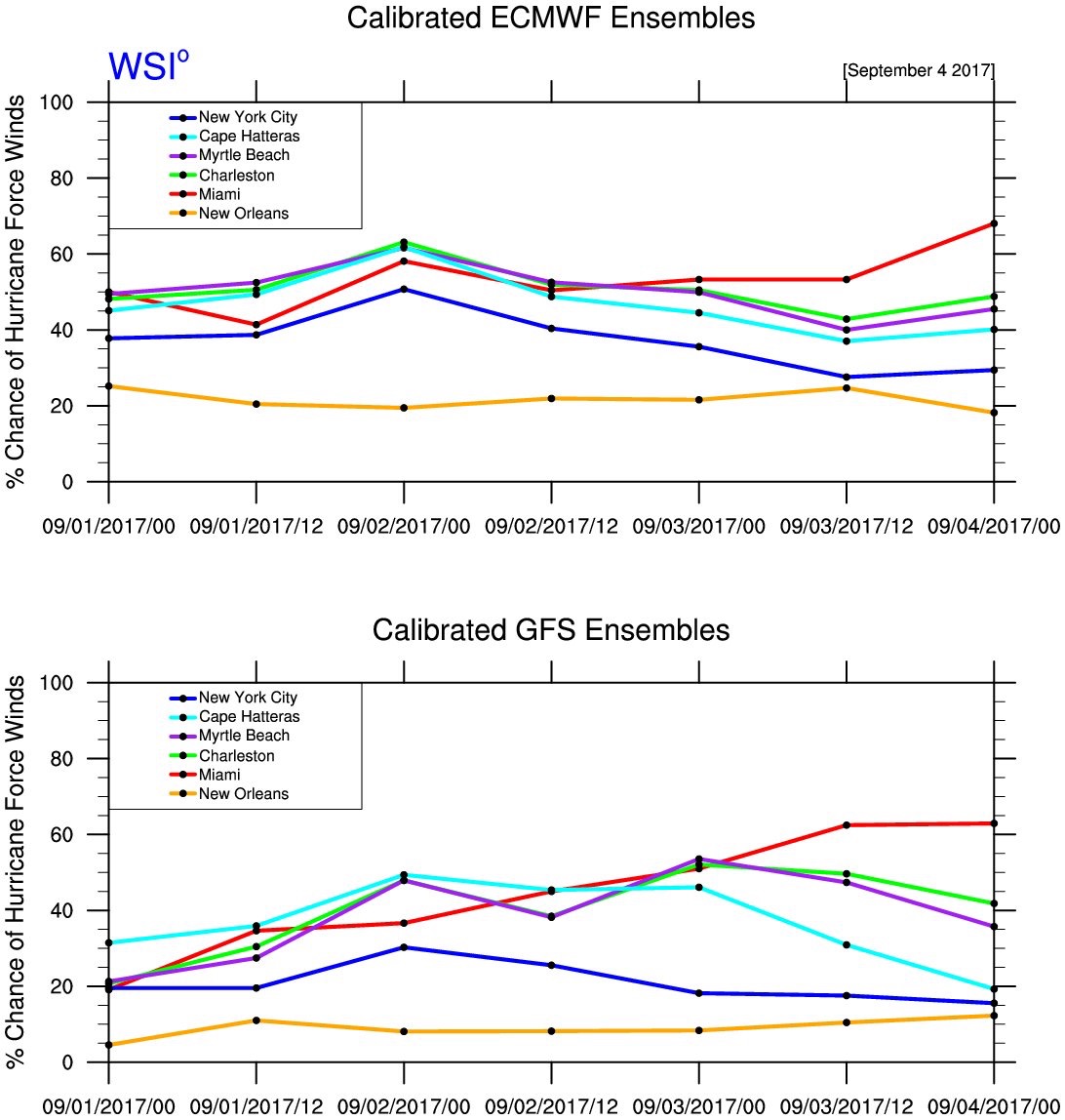
A useful graphic I stumbled upon. Probabilities of hurricane force winds at individual cities. Credit Michael Ventrice at WSI.

ska said:
Milk bought Sunday or Monday for a possible storm on Friday or Saturday is likely to be wasted.
Milk and eggs bought in Florida in anticipation of the loss of power are likely to spoil. I thought people only bought those things before winter storms.
I did buy eggs, and plan to hardboil them to have if when the power goes out. And shelf-stable milk for the coffee I'll make on my new sterno stove. By the light of my d-battery powered lantern. (can you tell I did a lot of storm-prep shopping today?) And all those ice packs from Blue Apron are going to be put to good use.
People here are getting worried. Not sure yet if it's justified, or exacerbated by how awful Harvey was.
Edited to add: State of Emergency declared for the entire state of Florida. I'm told this is standard when a hurricane's coming, but somehow it's feeling a lot scarier now.
A SOE is declared simply to allow for easier mobilization of supplies/emergency personnel. It would likely be declared for a tropical storm or a cat 5. That said, this is the real deal. Still plenty time to shift, but definitely continue to prepare. Matthew did this last year too and rode up the coast instead. This is still a plausible scenario.
ril said:
Edited to add: State of Emergency declared for the entire state of Florida. I'm told this is standard when a hurricane's coming, but somehow it's feeling a lot scarier now.
Major Hurricane Irma is expected to make the Lesser Antilles Islands tonight and Puerto Rico tomorrow.
Beyond fove days, the overall guidence in both the American and European models continues to shift slightly westward. The Florida Keys and South Florida are still within the trend, but the spread is still well over 250 miles at five days and still moves with every model run. This storm could still also end up in the Gulf of Mexico.
The storm behind Irma, not yet named, now looks unlikely to ve a threat to land.
From the NHC:
"KEY MESSAGES: 1. Irma is expected to affect the northeastern Leeward Islands as a dangerous major hurricane, accompanied by life-threatening wind, storm surge, and rainfall impacts. Hurricane warnings are in effect for portions of the Leeward Islands. Preparations should be rushed to completion, as tropical-storm force winds are expected to first arrive in the hurricane warning area later today.
2. Irma is also expected to affect the British and U.S. Virgin Islands and Puerto Rico as a dangerous major hurricane later this week. Hurricane warnings have been issued for these areas, and tropical-storm-force winds could arrive in these areas by early Wednesday.
3. Irma could directly affect Hispaniola, the Turks and Caicos, the Bahamas, and Cuba as a dangerous major hurricane later this week. Residents in these areas should monitor the progress of Irma and listen to advice given by officials.
4. There is an increasing chance of seeing some impacts from Irma in the Florida Peninsula and the Florida Keys later this week and this weekend. Otherwise, it is still too early to determine what direct impacts Irma might have on the continental United States. However, everyone in hurricane-prone areas should ensure that they have their hurricane plan in place."
On the satellite this morning, you can see how defined the eye has become, and that the storm has grown larger overnight:

in South Florida now- coastal area of Treasure Island/St pete. Supposed to head to Disney Fri-Mon.
Not sure what to do. Hate to waste $ to be at Disney if services are suspended. Makes me a bit nervous to ride out a hurricane a block from the beach/intracoastal.
Max, where can I find the latest model with the path/days it will hit each area (the cone images)?

A tip of the hat to the NOAA Hurricane Hunters.
Washington Post: Irma intensifies to an ‘extremely dangerous’ Category 5 hurricane on its track toward the U.S.
Hurricane Irma strengthened overnight to a dangerous Category 5 as it barrels toward the Greater Antilles and Southern Florida. It’s likely that Hurricane Irma will affect the U.S. coast — potentially making a direct landfall — this weekend. Tuesday morning, NOAA Hurricane Hunters found the storm’s maximum wind speeds are 175 mph. It now ranks among the strongest hurricanes ever recorded in the Atlantic Ocean. Forecasts suggest it will reach southern Florida and the Gulf of Mexico this weekend.

For those of you who don't know what a Cat 5, or any other Cat level, can do, here's an informative link:
http://www.nhc.noaa.gov/aboutsshws.php
This 175 mph, hurricane is well into Cat 5 territory. If they had a Cat 6, it would be listed as such. The 175 is the sustained wind. Currtenly the hurricane gusts to 210-215 mph.
ps - they think it may even intensify a bit more.
conandrob240 said:
in South Florida now- coastal area of Treasure Island/St pete. Supposed to head to Disney Fri-Mon.
Not sure what to do. Hate to waste $ to be at Disney if services are suspended. Makes me a bit nervous to ride out a hurricane a block from the beach/intracoastal.
I wouldn't go, considering its a Cat 5. You may not even be able to get transportation to there. If by some miracle you do manage to get there then write your Soc Sec number on your arm with indelible ink.
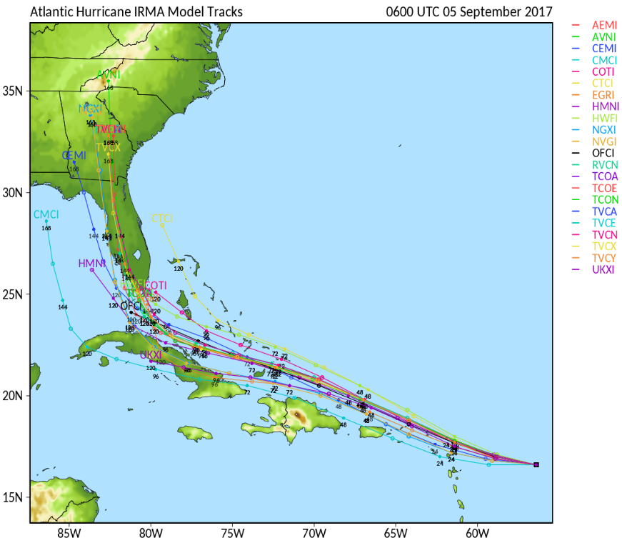
tropicaltidbits.com
conandrob240 said:
Max, where can I find the latest model with the path/days it will hit each area (the cone images)?
Sponsored Business


Promote your business here - Businesses get highlighted throughout the site and you can add a deal.
For Sale
-

REVO luggage $100
More info


Thank you, Max, and than you WxNut2.0. Reassuring to have voices of reason here.