Fall weather thread


Wed Sept 3rd
A bit warmer going into the weekend
Today, sunny, high near 80⁰, overnight low near 60⁰
Thursday, mostly sunny, high near 80⁰. Overnight slight chance of showers, low in the lower 60⁰s
Friday mostly sunny, high in the mid 80⁰s, a bit more humid, overnight lows around 60⁰
Saturday high mid 80⁰s, chance of showers
From Sunday it looks like we are back to a few days of mostly days with highs in the mid 70⁰s
Friday Sept 5th
After a bit of unexpected rain last night, today should still be mostly sunny, warm and a bit humid, high mid 80⁰s, overnight low upper 60⁰s
Saturday should become cloudy, warm and humid, with rain likely in the afternoon and overnight. If the rain moves in by mid day, there's a decent chance of more thunder. High in the mid 80⁰s, overnight temps start out in the humid upper 70⁰s but finally reach the lower 60⁰s
Slight chance of showers continuing into Sunday morning, then should clear up with pleasant temps in the lower 70⁰s, overnight lows in the mid 50⁰s
Monday and Tuesday should be sunny with highs in the 70⁰s
Friday evening update, Sept 5th
The front coming through tomorrow (Saturday) afternoon is looking like it could throw off some possibly serious thunderstorms, and NOAA's Storm Prediction Center has our area at a slight (+/- 5%) risk of a tornado. While this means a tornado is not likely, it does mean that these storms could have strong gusty winds, heavy rain, and possibly hail. Timing right now looks to be in the mid to late afternoon, with a window from 3 - 9 pm. Once they arrive, they should lost about 1 - 2 hours.
As always, please do not rely on me for timely warnings but rather have your phone on and set to give you alerts from FEMA or another trusted source (I know, I know, but there it is).
From the NWS:
Hazardous Weather OutlookNational Weather Service New York NY207 PM EDT Fri Sep 5 2025CTZ005-006-009-NJZ002-004-006-103>108-NYZ067>074-176-177-061815-Northern Fairfield-Northern New Haven-Southern Fairfield-Western Passaic-Eastern Passaic-Hudson-Western Bergen-Eastern Bergen-Western Essex-Eastern Essex-Western Union-Eastern Union-Orange-Putnam-Rockland-Northern Westchester-Southern Westchester-New York (Manhattan)-Bronx-Richmond (Staten Island)-Northern Queens-Northern Nassau-207 PM EDT Fri Sep 5 2025
This Hazardous Weather Outlook is for southern Connecticut,northeast New Jersey and southeast New York..
DAY ONE...This afternoon and tonight.Hazardous weather is not expected at this time..
DAYS TWO THROUGH SEVEN...Saturday through Thursday.Thunderstorms will develop ahead of a cold front Saturday. The main threat is damaging winds, although an isolated tornado is possible.In addition, heavy rain will likely produce areas of urban and poor drainage flooding, along with a localized flash flood risk..
SPOTTER INFORMATION STATEMENT...Spotter activation will likely be needed.&&
This Hazardous Weather Outlook provides a summary of potential widespread hazardous weather events that may reach NWS warning criteria. Most long fused NWS watches, warnings, and advisories in effect are highlighted.
Please refer to the latest NWS forecasts for weather not meeting NWS warning criteria.$$
Monday Sept 8th
Another nice week ahead
Mostly sunny this whole week, with highs in the mid 70⁰s up to maybe 80⁰ Wednesday and overnight lows in the mid 50⁰s. The only chance of rain is a very slight one on Wednesday. Even next weekend looks nice from here. Boringly delightful in general 🙂


Wed Sept 10th
Some showers remain in the area this morning, clouds keep things a bit cooler today, high near 70⁰
Thursday warmer, sunny, high near 80⁰
Friday and the weekend continue dry and mostly sunny, highs upper 70⁰s to near 80⁰
Overnight lows in the upper 50⁰s throughout
Monday Sept 15th
Continued warm, chance of rain Wednesday
Today, mostly sunny, high near 80⁰, overnight low near 60⁰
Tuesday, more clouds, especially in the afternoon, high upper 70 low near 60⁰, slight chance of showers overnight
Wednesday, chance of showers has diminished in latest model runs but for now is still in the forecast, otherwise cloudy, high lower 70⁰s low lower 60⁰s
Thursday clearing high near 80⁰, Friday sunny and warm high mid 80⁰s
Early weekend forecast is nice, sunny and cooler
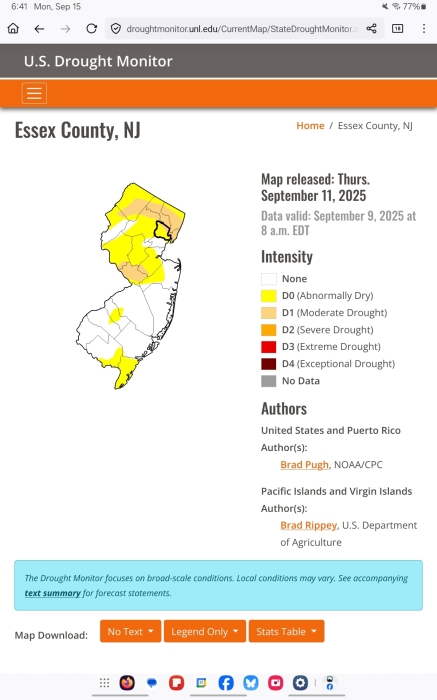
Unfortunately we are back to abnormally dry conditions even with the recent rain and this week is not likely to bring relief. No official warnings but be prudent with outdoor fires
Wed Sept 17th
Showers likely this afternoon, then a sunny weekend likely ahead
Today, showers, slight chance this morning becoming likely this afternoon. Breezy, high only in the upper 60⁰s, low lower 60⁰s tonight
Thursday clearing, high upper 70⁰s low lower 60⁰s
Friday sunny, high near 80⁰, chilly mid 50⁰s overnight
Saturday and Sunday seasonal and sunny, high low 70⁰s low upper 50⁰s
Monday, Sept 22
All good things must end, and so it is with our sunny days, so enjoy this last one
Today, mostly sunny, warm, high in the mid 70⁰s, overnight low around 60⁰
Tuesday starts off warmer. Depending on when the clouds roll in, could easily hit the lower 80⁰s and get humid. Showers become more likely, in the late afternoon and overnight, low mid 60⁰s
Wed chance showers high upper 70⁰s low mid 60⁰s
Thursday chance showers high mid 70⁰s
Friday and Saturday lower 70⁰s and chance showers
Throughout the period, possible heavy showers but timing is still uncertain, Wednesday could see a thunderstorm although more likely north and west
Guess autumn is really here
Wed Sept 24th
Warm and wet weather this week
Today, cloudy, showers possible this afternoon becoming rain likely overnight. High near 80⁰, low upper 60⁰s
Thursday, rain likely, and possibly a thunderstorm. High upper 70⁰s, low mid 60⁰s
Friday chance of showers, high upper 70⁰s, low lower 60⁰s
Saturday starts out cloudy with a chance of showers in the morning, then cloudy, still a bit humid, high mid to upper 70⁰s, low lower 60⁰s
Sunday mixed clouds and sun, upper 70⁰s
Monday Sept 29th
A fair week
Today, partly cloudy and warm. A bit less humid. High upper 70⁰s, overnight low low 60⁰s
Warmer Tuesday, still some clouds, high in the lower 80⁰s, low mid 50⁰s
Wed and Thurs clear, sunny, cooler and less humid. Highs mid 60⁰s low upper 40⁰s (!)
Friday and Saturday looking nice, sunny and dry, highs in the 70⁰s and cool overnight near 50⁰
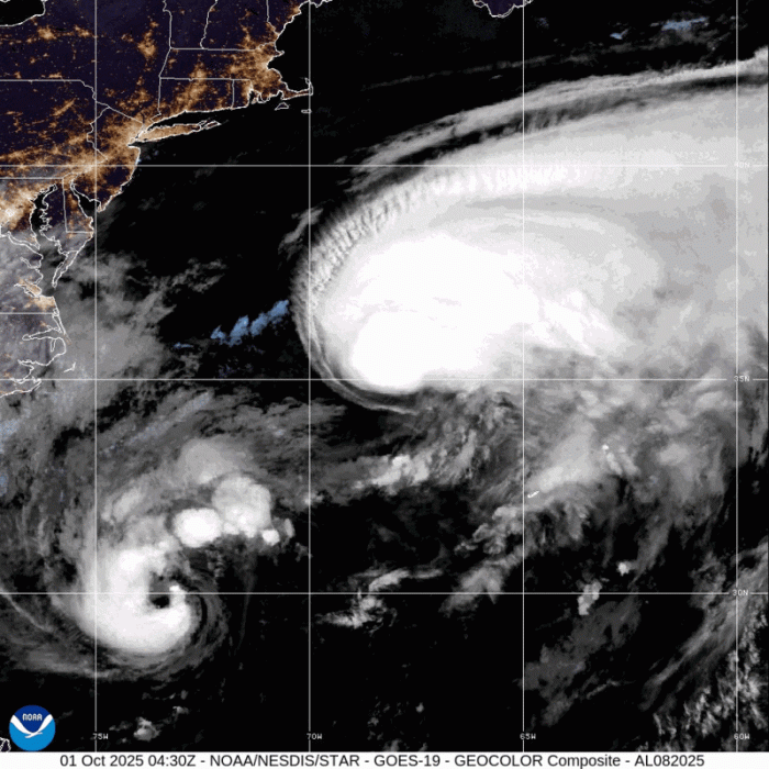
A note on tropical storm Imelda. This storm is trending out to sea now and should not be a significant threat to land in the continental USA. Earlier model runs showed a major hit to the southeast, and the storm will be watched closely, but the trend is favorable. Mark Furman asked last week about the Fujiwara effect, which is something that can happen if two tropical storms are close together physically. In this case, the effect is forecast to pull Imelda away from the coast as it gains proximity to Humberto.
Model image from the gfs model showing wind circling both storms as they interact tomorrow morning


mjc said:
(that map looks like it belongs in an Australian-birds thread)
the uncaged birds…
Wed Oct 1st
Fair weather ahead, a cool end of the week and warmer weekend
Today and tomorrow, a few clouds but mostly sunny, still cool with highs in the upper 60⁰s and lows around 50⁰
Friday mostly sunny and a bit warmer, high in the lower 70⁰s
Saturday and Sunday should be warmer, sunny, highs around 80⁰ and lows in the upper 50⁰s
And here's a pretty picture of Imelda and Humberto doing their dance out in the Atlantic. That's Humberto on the right. If you head for the beach this weekend, be very aware of rip currents and rough surf from this combined system (if you click it it moves)
Monday, October 6th
One last summer day
Today, warm, dry, some clouds. High mid 80⁰s, overnight low high 50⁰s
Tuesday clouds roll in in the afternoon, overnight showers likely. Cooler, high near 70⁰, low around 60⁰
Wednesday likely early am showers (and possibly a thunderstorm) clear up by mid morning. Cooler, high near 70⁰ low Wed night in the 40⁰s
Thursday through the weekend looking nice. Cool and clear with highs in the 60⁰s and lows in the 40⁰s
Wed Oct 8th
Fall arrives
Today, rain showers ending mid morning, the breezy. High upper 60⁰s, low overnight mid 40⁰s
Thursday and sunny and cool, highs low 60⁰s lows mid 40⁰s
Saturday gathering clouds and a bit warmer high upper 60⁰s low lower 50⁰s
Sunday and Monday we might see out first nor'easter of the season with rain and wind but for now going to say chance of rain Sunday into Monday as the storm also could be out to sea. Either way we'll keep an eye on it
Friday October 10th Weekend Update
First, sorry about leaving Friday off my last post. Guess I was in a hurry to get to the weekend!
So, Friday sunny, high in the low 60s, overnight low lower 50s.
Saturday sees gathering clouds with a slight chance of showers overnight becoming showers likely after midnight. We will start getting a bit of a breeze overnight but nothing to worry about. High upper 60s to 70 depending on how fast the clouds move in, low mid 50s.
Sunday gets interesting. We are expecting a nor'easter to pass by off the coast. How far off the coast and exactly when is still a matter of some debate. The GFS model is bringing the rain in the afternoon, but the Euro doesn't really get going until after dark. Either way, we are looking at a solid 24 - 36 hour rain event, which is good -- 1" to 2" spread out like that will give us a good soaking at a rate the ground can absorb, so little to no flooding and much benefit.
Also Sunday we will be getting wind. The steady 15 - 20 mph is no howler, and the gusts are forecast to only get up to 30 mph, so damage should be minimal. High and low temps should hover between 55 and 60.Note that the rain and the wind are likely to be significantly worse down the shore and on Long Island, so we will be hearing wind and rain watches and possibly warnings for nearby areas.
This type of storm also can produce coastal flooding as the wind and tide combine to drive the surf. Again, not a threat to MAPSO.
The wind and rain will probably continue most of the day Monday. Temps likely to continue to hover between 55 - 60. May get a bit of thunder Monday, but not likely to be anything serious.
The WPC graphic below is mostly focused on the coast, so don't let it scare you, the effects of the storm should be milder here.

Sun Oct 12th
Forecast is on track for a nor'easter bringing rain and wind
Chance showers this morning, then steady rain likely this afternoon, continuing through tonight and all day Monday, tapering off after midnight Monday night. Total rainfall for the period 1 - 2 inches.
Steady winds around 20 - 25mph with gusts in the 30s, definitely enough to really shake the sukkah.
I do not expect anything more than minor nuisance flooding, the warnings that you might see are for coastal flooding as wind drives tides onshore along the coast.
The good news is (1) we need the rain and this is the best sort of rain, slow and steady and soaking, and (2) by Wednesday we should be back to fine sunny autumn days for awhile

Thank you, Max! Between those two posts there was a ton of scary meteorological accounts on FB and elsewhere posting about this storm, with some headlines comparing it to Sandy and I was really hoping we would get a calming hyperlocal post from you laying it out how it is, so I really appreciate you giving me one less thing to freak out about this weekend.

We did stash our patio umbrellas in in the garage and cleaned up a few things that could have gotten blown around in the gusts. Nice to know this is most likely a manageable storm for us.
Monday October 13th
Forecast on track for light to moderate rain all day and less windy conditions
Today the rain continues, light to moderate, gradually tapering off later this afternoon and tonight to a slight chance by Tuesday morning. Wind still present although the worst is probably over, we may still see some gusts close to 30mph this morning. Some wind continues throughout the day, and into the night. High and low, mid 50⁰s
Tuesday some clearing, may see a bit of sun in the afternoon, high lower 60⁰s
Wednesday mostly sunny, high mid 60⁰s low 40⁰s overnight
Thursday and Friday should continue sunny with highs in the lower 60⁰s and lows in the 40⁰s
Weekend looking mostly sunny with highs in the upper 60⁰s

Wed Oct 15th
Fair Fall weather ahead
Today, mostly sunny, a bit breezy, high upper 60⁰s, overnight low 40⁰s
Thursday, Friday, and Saturday sunny, high near 60⁰ low lower 40⁰s, breezy
Sunday some clouds, especially in the afternoon, high near 70⁰ then rain possible overnight, breezy
Sun Oct 19 update
There is likely to be some thunder and lightning as the squall line moves through tonight, with brief periods of heavy rain and gusting winds. The rain, likely after midnight, may persist into the early part of the Monday morning commute.
Monday breezy with chance of light rain diminishing as the day progresses
Tuesday clear and sunny and cool
High today in the mid 70⁰s with gathering clouds, rain overnight likely
Highs Monday and Tuesday in the mid 60⁰s
Monday October 20th
At 7:00 this morning, there are still a few showers in the area. They should move through in the next hour or so, then breezy but mostly dry today, even some sun this afternoon. High near 60⁰, low tonight mid 40⁰s
Tuesday should be sunny during the day, high mid 60⁰s. Overnight could see some showers but nothing serious although it gets breezy again, low near 50⁰
Showers might carry into Wednesday morning, breezy
Thursday and Friday, clearing, continued breezy, high near 60⁰
Friday Oct 24th
Cool and clear for the weekend
Today, sunny high near 60⁰
Saturday same, Sunday a bit cooler and some clouds mixed in
Monday and Tuesday mixed su.n and clouds, high mid 50⁰s
Lows around 40⁰ but there is a slight chance of patchy frost, especially Sunday night, so get those most fragile plants under cover
Monday, October 27 (ok, a little early)
The main feature of the week's forecast is the complex low pressure system coming through midweek, likely bringing showers and gusty winds. The system has three parts coming from three different directions; it's a bit tricky trying to get timing and rainfall right at over 100 hours out. So lots of qualifications, hesitations, and a bit of guessing.
Here's my best try:
Sunday night: Clear and chilly, low around 40
Monday and Tuesday, mostly clear and sunny. High mid 50s, low around 40 overnight, Tuesday night slight chance of rain and breezy
Wednesday, mixed sun and clouds, breezy, high upper 50s low mid 40s, overnight chance of a shower
Thursday, rain likely. If the system shapes up like I think it will, we will have a period, probably Thursday night, of showers and some heavy showers possible. Blustery winds likely with some gusts possibly approaching 30mph. High near 60, low in the upper 40s
Friday chance of showers, high near 60, low mid 40s. Showers are likely to taper off in the afternoon and evening. Fingers crossed we should be dry for trick or treating
~~~~~~~~~~~~
The maps below are the current runs of the GFS and Euro models. Although they have some timing differences, they both show the storm's comma shape and the line of heavier showers moving through the area Thursday afternoon and evening. If you look in the lower right corner you can see hurricane Melissa, which poses no threat to us at all, but is showing up as a tight and powerful storm which will head out to sea and not towards us


Rentals

Sponsored Business


Promote your business here - Businesses get highlighted throughout the site and you can add a deal.
Advertisement


Monday Sept 1st
Fair weather continues through Wednesday, then several chances of showers Thursday through the weekend. Temps remain a few degrees cooler than normal
Today through Wednesday, mostly sunny. Highs in the upper 70⁰s. Overnight lows upper 50⁰s to lower 60⁰s
Thursday starts out mostly sunny, showers could develop in the afternoon or evening, temps high upper 70⁰s, low around 60⁰
Friday through the weekend more cloudy, chance of showers, highs upper 70⁰s lows upper 50⁰s to lower 60⁰s