S-curves....straighter??

Whenever I drive there I feel like I have less control of the car than I've had in the past. Perhaps this feeling will diminish once the construction lanes and dividers are gone. The changes I'm noticing are the ugly, freshly stamped retention walls and bridges and oodles of new street lights---and, I like neither because they take away from the natural look of the park.


It was never meant to be straighter from what I understand. The changes had to do with drainage issues I believe.


Here's an article from 2014 explaining the goals of the redesign of the "s" curves:
http://www.northjersey.com/news/work-begins-on-s-curves-1.998482
Making the curves safer and improving drainage are both mentioned.
I think it's hard to evaluate when the work is still ongoing. Hopefully the end result will be an improvement.

They were obviously never going to get rid of the curves, but my understanding is that they were going to be "relaxed" in some sense. It's hard to tell while the construction still continues.
It definitely appears to have been a boondoggle, though. I think that they could have done this job for a lot less money and still accomplished the needed re-engineering as well as associated plantings, functional new footbridges, etc.
Noticed that sight lines have been improved in a lot of areas. Many, but not all the blind curves have been eliminated, especially westbound. My biggest fear on that road was coming around a curve to find a traffic jam or a stalled car.

wendy said:
It was never meant to be straighter from what I understand. The changes had to do with drainage issues I believe.
I agree. For as long as I was driving the S curves, poor drainage and flooding made the road a hazard. Then, in the last number of years before the redesign the east-bound lane was starting to slide into the ravine, adjacent to the road, half way up the S curves.
Glad they fixed the drainage. Hate the lighting and bridges at the top and bottom of the hill.

Thank you for the link to the article. I forgot about the drainage thing.
I was talking about it in the car with my husband and I really do always give the People In Charge of stuff like this the benefit of the doubt, and I was explaining my confusion in a diplomatic way to my husband... My 5 year old piped up from the back of the car, "Maybe they can't see. The workers, I mean, maybe they can't see. And that's why it doesn't look any different."
I will see if I notice a lack of blind curves next time I go through.

I've spoken with my wife about this and she assures me relaxing is temporary and as soon as we have a very humid day they will spring right back to tight curls.

The better option, of course, would have been to construct an earthen dam from ridge to ridge with the road on top. We would have had a nice straight road and flood control in one project.


I think the improved drainage will last until the first snow storm. Then the roads will be torn apart by the snow plows and we'll be faced with poor drainage and horrible potholes....

Well, the drainage work is extensive and not on the road, so I'm pretty sure it will be okay.


Here's the original plan, but a local environmental group's opposition prevented the project from going forward:

Who is responsible for giving a green light to this project? Under whose direction would this have been suggested? Just want to know for any future political decisions if applicable.

From the link above:
When Essex County Freeholder Patricia Sebold spoke during a press conference this past Monday, she recalled when her daughter's friend died in a car crash while driving through the "S Curves" on South Orange Avenue about a decade ago.
Essex County Sheriff Armando Fontoura said during the conference that he, too, has heard about and witnessed several accidents along the twisty thoroughfare, which runs through South Mountain Reservation.
Sebold and Fontoura as well as other county officials and politicians at Monday's event agreed that the road is dangerous and needs to be made safer for motorists and pedestrians.
Now it will be. New Jersey Gov. Chris Christie has given Essex County the go-ahead to enhance the road and the drainage along it. The county is receiving $30 million in federal funding for the project.
"The governor was supportive. If it wasn't for his support, we would have lost the $30 million," said Essex County Executive Joseph N. DiVincenzo Jr. Monday.
Work started earlier this month to redesign the 1.6-mile stretch of roadway, which runs through South Mountain Reservation. Changes include realigning the road to reduce the sharpness of the curves, widening the road so a shoulder can be created in the eastbound direction, and adding retention swales along the side of the road. The swales will alleviate flooding and reduce water runoff from the road into the reservation. A new pedestrian bridge will be constructed over the road near the Girl Scout camp, and the existing pedestrian and equine bridges will be reconstructed. The two bridges will be designed with stone facing to complement the natural area of the reservation, according to Essex County officials.
Other modifications include installing guard rails and lighting along the road with traditional overhead cobra-head street lights and decorative gas-lamp style lamps, upgrading the turnoff and parking areas along the road, making it easier for motorists to enter and exit from them, and upgrading the traffic signal equipment at the intersections of South Orange Avenue and Brookside Drive/Cherry Lane in Millburn and South Orange Avenue and Glenview Road in South Orange.
DiVincenzo has been working toward getting federal funding for the project for the past 10 years, since the Federal Highway Administration had identified this section of South Orange Avenue, which runs from Brookside Drive to Harding Drive, as deficient because the road floods regularly and is usually closed to traffic during inclement weather. The sharp curves in the road and the lack of a shoulder result in limited sight lines, and make it difficult for motorists to enter and exit existing turnoff areas.
Whenever it snows, we have to immediately close the road," DiVincenzo said.
He noted, "The sharp turns and lack of shoulders on the side of the road create hazardous driving conditions."
According to Fontoura, more accidents have occurred on this stretch of the road than any other county road. Upgrades the "S Curves" will make people safer, Fontoura explained, noting the county will make sure all the equipment works properly and the road is built efficiently during and after construction.
One lane of South Orange Avenue will remain open to traffic at all times during the project.
"This is not the Pulaski Skyway," Fontoura said, "We will be open."
Also as part of the project, trees and other landscaping will be planted to replace the 430 trees that were cut down so the road could be widened. Vegetation will be replanted in areas of the reservation that were affected by Hurricane Sandy, according to county officials.
The S Curves Project is expected to take two years to be completed. Currently, work is being done on time and on budget, explained an official with New Prince Concrete Construction Company, Inc.
"So far, so good," the official said.
Hackensack-based New Prince Concrete Construction will be doing the construction work. The company was awarded a publicly bid contract for $25,915,389.50 to perform the construction, according to Essex County officials. Wall-based French and Parrello Associates, Consulting Engineers designed the roadway improvements with a $1.6 million contract it received for the work. The Essex County Public Works Department is monitoring the project to prevent delays, according to county officials.
http://www.northjersey.com/news/work-begins-on-s-curves-1.998482
[emphasis mine]

Is this a joke?
max_weisenfeld said:
Here's the original plan, but a local environmental group's opposition prevented the project from going forward:
BubbaTerp said:
Is this a joke?
max_weisenfeld said:
Here's the original plan, but a local environmental group's opposition prevented the project from going forward:
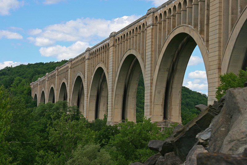
If someone had offered to build something like the Paulinskill Viaduct across the valley, I am sure there would have been a pocket of vocal opposition.
BubbaTerp said:
Is this a joke?
max_weisenfeld said:
Here's the original plan, but a local environmental group's opposition prevented the project from going forward:
are you joking by asking if it's a joke?

Thanks for posting that @mjh. I guess by the metrics laid out in that post, we'll know if it's a success by noting if there are fewer accidents, and fewer fatal accidents, following completion of the project (proportional to traffic volume)?
PVW said:
Thanks for posting that @mjh. I guess by the metrics laid out in that post, we'll know if it's a success by noting if there are fewer accidents, and fewer fatal accidents, following completion of the project (proportional to traffic volume)?
Much of the reduction in traffic fatalities over the years can be attributed to improved road engineering.

oh i thought this project was done not too straighten the curves, but to spend lots of our tax money while at the same time making the road more dangerous during its construction period, cut down a bunch (big bunch) of mature trees, and just generally inconvenience the public...
Equine bridge????? Ha for all that horse travel.. does Joey D. have a stable in the works???
Possibly, if he can only figure how it would put money in his pocket.
While the stables in the Reservation are long gone, several of the trails are still maintained to the level that horse riders would need. Why? I don't know.
Ok, Mr. Weisenfeld, I'll bite. Is that the Tunkhannock Viaduct, the engineering marvel that the Delaware, Lackawanna & Western R.R. built in Pennsylvania? If so, in years past passengers from SOMA could have traveled over it between Hoboken and Buffalo.
tjohn said:
Paulinskill in N.J.
Tjohn wins, but yes, you could ride it regularly. You still can, but note that hopping freights is illegal.

tjohn said:
BubbaTerp said:If someone had offered to build something like the Paulinskill Viaduct across the valley, I am sure there would have been a pocket of vocal opposition.
Is this a joke?
max_weisenfeld said:
Here's the original plan, but a local environmental group's opposition prevented the project from going forward:
If it were a valley to be crossed, you might have a point. Was there around 10 years ago, and only seeing it gives a sense of the amazing scale. Our group also walked over the Delaware River Viaduct which passes over I-80 as you approach the Water Gap.
http://www.vacantnewjersey.com/locations/paulinskillviaduct/main.html
http://www.headfirstadventures.com/2013/02/07/concrete-arches/
It's already clear that the final result of this huge project will be to change what was a minimally intrusive drive following the easiest route though a forest, largely unchanged since the road was built in 1811, into a trip through an ugly man made with two nice new bridges overhead. In prior discussions about the finish of the fake stone concrete retaining walls, known as form liners, I held out the hope the surfaces would be stained to make them appear more like stone, and the uneven joints would be smoothed over. This is a readily available choice, but is more costly than lane divider white. This would have been part of the construction process, so I fear the white walls are there to stay. It's a shame that someone with more knowledge of sympathetic materials wasn't part of the process.
I also remain shocked at how much was involved in trying to ensure every possible hazard was removed from this route. The drainage absolutely needed to be fixed, but it's sad how we've lost a unique (for suburban NJ) experience in the name of safety that in all probablity could have been solved less intrusively with a more sensitive hand.
For Sale
-

REVO luggage $100
More info


Free Items
Rentals
-
Huge Brand New construction Apartment in 2 family home with 4 bedrooms 3 bathrooms
4 Bd | 3Full Ba
$4,500

I was happy to give the planners the benefit of the doubt with the S-curve project, but it's starting to look rather permanent now (barriers, etc) and I cannot for the life of me figure out where the S-curves are straighter or in any way improved. Can anyone shed some light on this for me?