Winter Weather Advisory, Snow Likely Monday Evening - Tuesday 3/12 - 3/13

Snow looks likely now.
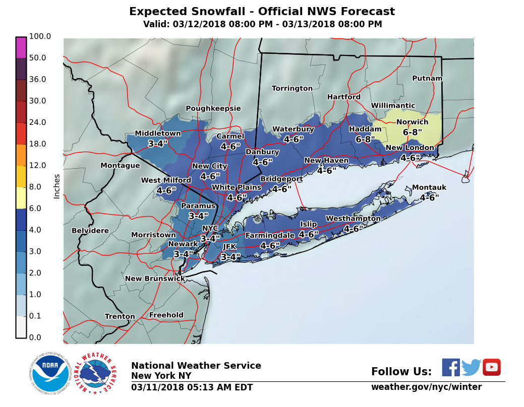
Overnight model runs continue to be inconclusive, but signals for several (3-5") inches of snow in our area are increasing, and with the tendency for the forecast to shift in our direction in the last 48 hours before a storm, it is prudent at this t ime to expect at least some of the forecast snow to happen.
This is another two-part system with the potential to become a serious storm. While it is still unlikely that we will feel the worst effects if the storm fully develops, we are at this time likley to see some snow or a wintery mix overnight Monday into Tuesday.
We will have more confidence in the forecast tonight.

Given the temperatures, would it be another wet, heavy snow like the last one?

max_weisenfeld said:
Snow looks likely now.
Overnight model runs continue to be inconclusive, but signals for several (3-5") inches of snow in our area are increasing,
NotoriousEAM said:
Given the temperatures, would it be another wet, heavy snow like the last one?
I'm sorry, but both of you need to wash your mouths out with soap talking like that, using language like that is just wholly unacceptable


DiMartino (I know, I know) half an hour ago said coating to an inch. Hoping he's right.
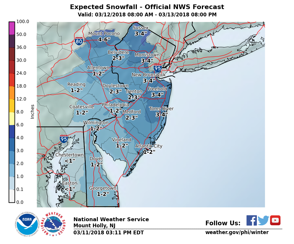
Forecast update.
Forecast remains on track for 3 - 4" of wet snow Monday night and Tuesday.
While the headlines will say "nor'easter" this one is still leaving me cautiously optimistic. Not that we need any snow at all, but this is still looking like slow accumulating 3 - 4" here in MAPSO, with significantly more dire forecasts further east, especially eastern Long Island, that will be the headlines in all the TV weather reports.
We are not entirely out of the woods yet -- this has the potential to be a serious storm, and that storm, should it happen, has the potential to strike here. However, it is more likely that the storm will pass to our east, and that we will be on the fringe. Unfortunately, we will not know for sure, with this one as with the other recent storms, until it is just about right on top of us -- or rather, with luck, NOT right on top of us!
With that then, the forecast is clear tonight.
Tomorrow, rain late changing over to snow before midnight, earlier if the precipitation is heavier.
Snow continues Tuesday morning, total accumulation 3 - 4"
Snow ends Tuesday afternoon or evening.
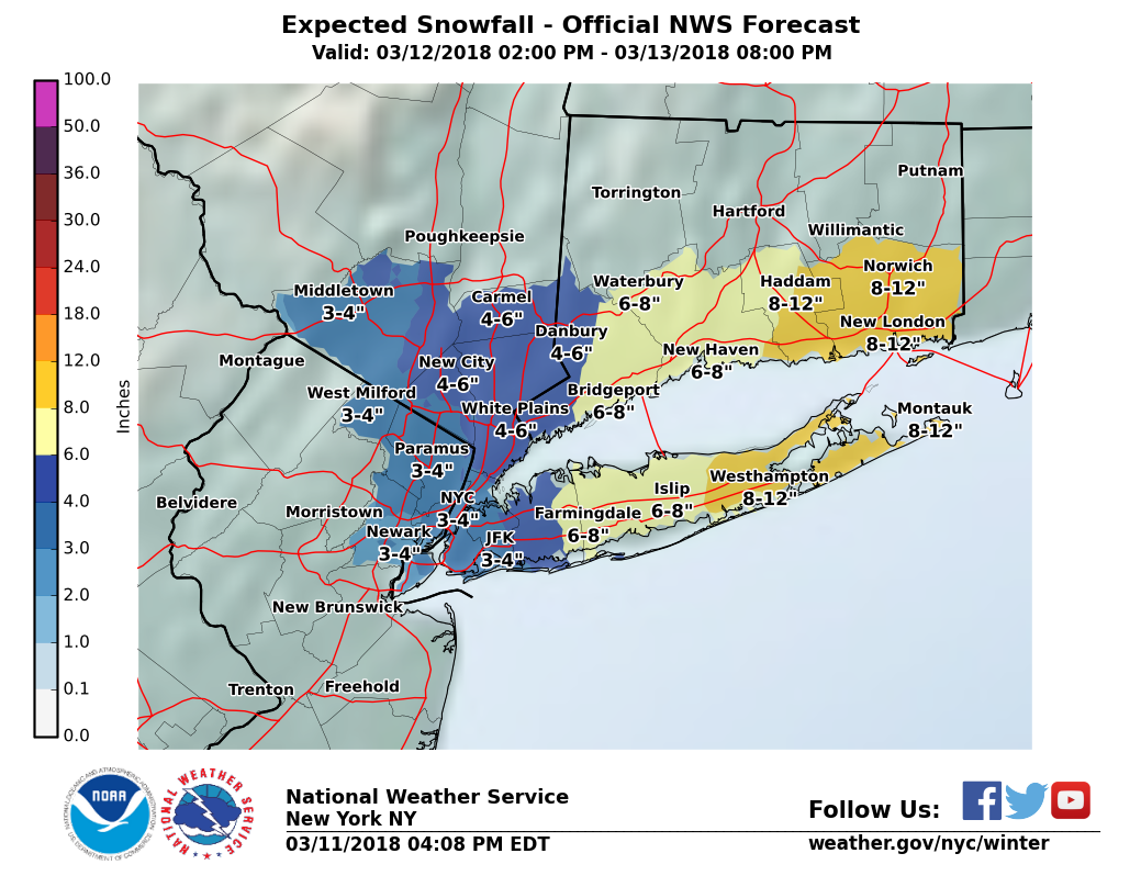

While there is still some significant uncertainty with this system, the bulk of the guidence is pretty good for us. We still get snow, but only 2 - 3" and that will be (1) over an 8 - 10 hour span, and (2) could have trouble sticking to road surfaces. So I remain cautiously optimistic.
Still, snow is snow and the NWS has issued a Winter Weather Advisory (see below) for our area.
Forecast: gathering clouds today with highs around 40.
Precipitation may start as rain this evening, changing over to snow, light or moderate at times.
More snow overnight, ending mid morning tomorrow.
Total 2 - 3 inches.
There is still the potential for much heavier snow with this system, most likely to our east, so please continue to monitor the forecast.
From the NWS:
"Winter Weather Advisory
URGENT - WINTER WEATHER MESSAGE
National Weather Service New York NY
330 AM EDT Mon Mar 12 2018
NJZ004-006-104>108-NYZ071>075-176-178-121730-
/O.NEW.KOKX.WW.Y.0012.180313T0000Z-180313T1600Z/
Eastern Passaic-Hudson-Eastern Bergen-Western Essex-Eastern Essex-
Western Union-Eastern Union-Southern Westchester-
New York (Manhattan)-Bronx-Richmond (Staten Island)-
Kings (Brooklyn)-Northern Queens-Southern Queens-
330 AM EDT Mon Mar 12 2018
...WINTER WEATHER ADVISORY IN EFFECT FROM 8 PM THIS EVENING TO
NOON EDT TUESDAY...
* WHAT...Snow expected. Total snow accumulations of 2 to 4
inches are expected.
* WHERE...Portions of northeast New Jersey and southeast New
York.
* WHEN...From 8 PM this evening to noon EDT Tuesday.
* ADDITIONAL DETAILS...Plan on slippery road conditions,
including during the morning commute on Tuesday. Be prepared
for reduced visibilities at times.
PRECAUTIONARY/PREPAREDNESS ACTIONS...
A Winter Weather Advisory for snow means periods of snow will
cause primarily travel difficulties. Be prepared for snow covered
roads and limited visibilities, and use caution while driving.
Check local Department of Transportation information services for
the latest road conditions
Winter Weather Advisory"

Rats! And if I got over a foot in South Orange when you guys got only 7", I wonder if I will make it up my hill if I go out tonight.
And that further delays all of the downed tree cleanup on my property.
Enough! I want my daffodils!

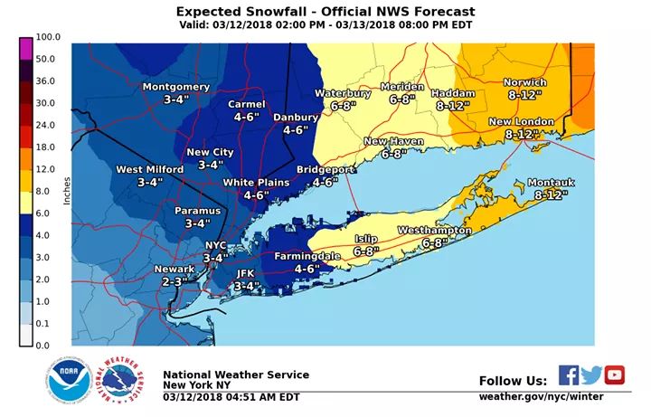
NWS still calling for 2-4 in our area, with Long Island getting 4-10 and higher in spots. But Southeastern Massachusetts is in line to get hammered. One to two feet of snow, with the low set up over the Cape Cod Canal and lots of cold air streaming in from the northwest keeping it all snow. Man, after seeing what 20+ inches did to Morristown last week, I feel for these folks.
We were without power from Wednesday 3 PM through last night at 7 PM, and the only reason we got back up last night was that News 12 did a feature on our particular downed wire that got the Mayor, Fire Chief, and JCP&L all em-bare-assed. But the damage from the storm was incredible in our area. The last one was as much a wind event as anything, but this time it was pure water weight.

We were high fiving on my block about our luck re power until we got hit with a "controlled" power outage on Saturday that seemed to get out of control. They shut our power off in connection with repairs elsewhere and couldn't get it back in for more than a day, with lots of conflicting postings about what caused the problem and how long it would take to fix.
Oh man, this is not the thread to go into how the power companies responded--or failed to respond--but I sent a very specific and detailed list of ideas to Governor Murphy this morning on things that JCPL and others can and should do better. Starting with: What happened to all the money they got in tax breaks, rates hikes, and grants after Sandy to improve the resiliency and response in the system? It is such a weird situation where private monopolies are granted by the state, but the state has little to no influence in return.

My beef this time, as during Sandy, is the ineptitude and outright falsity of their customer service communications. Twice on Saturday, thy called us to say our power was on (false) and when we said no, they insisted our neighbors had power (false). There was more BS I'll leave out. Their ignorance was particularly inexcusable in a situation like ours where one of their crews actually shut the power on purpose.
Nothing much changing except the NWS is moving the start period of the fun stuff for NYC and Long Island up to around midnight.
Yes, I am sticking with 1 - 3" of accumulation. A bit more may fall, but it will settle over the 10 hour course of the snowfall, so net will be lower, and lower than that on paved surfaces.

I am supposed to do a talk in Westchester (Harrison) on Tuesday evening. What should I expect up there>
...and tell you what it says. I do take a closer look at the particular conditions around here, but I have not spent enough time on the rest of the region to confidently say my forecast is better than the NWS. Trust the pros.


NWS is my go to for day to day, but I always check in with you (max) for any hyper-local forecasts.

But Max, my brother’s sister’s aunt’s cousin is flying in to Philly. Next week. Should they change flights from the 10am Tues arrival to 2pm Tues? How will the roads be? Meat? Oh, and separately, can I order an Uber to the airport at 5am?
max_weisenfeld said:
Don't mean it to be snarkey, but to answer your questions, I would do this: https://forecast.weather.gov/MapClick.php?lat=40.9701&lon=-73.7122#.Wqc0CnxG2Hs
...and tell you what it says. I do take a closer look at the particular conditions around here, but I have not spent enough time on the rest of the region to confidently say my forecast is better than the NWS. Trust the pros.
Been snowing since 9:30 last night, and here in eastern Maplewood it is begining to stick to road surfaces. Storm is performing to expectations.
Forecast: Moderate snowfall, ending midday, 1 - 3" total accumulation with higher amount at higher elevation. With temps remaining above freezing all day, streets may be a bit slick so be careful, but ice should not be a significant issue.
Simulated radar from the NWS for the next few hours: https://m.facebook.com/story.php?story_fbid=1995750723787566&id=177148895647767
Snow is starting to pivot out of our area, already done to our west. We should be tapering off between now and 1:00, with only a small snow shower or two for the rest of the afternoon.


Looks like they dialed down the temp forecast for this weekend -- a couple days ago I saw highs in the low 50s, now it's just low 40s.
And, another storm possible next Tue-Wed!!?!? Weather Underground showing 60% chance of snow, 6-7 inches possible.
Man the weather has really sucked recently. It's mid-March and the lion is still roaring.
A bunch of low level troughs will be passing through the next few days, meaning snow squalls, perhaps some rain (more likely snow), not much accumulation. Windy tomorrow. Dry on Saturday with a high pressure ridge, but still colder than normal.
And, yes, it is looking like another coastal storm is winding its energy up for Tuesday into Wednesday with the potential for more snow, although the models are not yet in agreement as the weather-wise like to say.
That should be it for today. Cannot accurately measure snowfall. By the time snowfall ended at 12:30pm, temps had risen and snow was melting on contact with the board. The cleared side of the board (cleared at 7:00am) was stll clear. The uncleared side had less depth, and snowmelt was running off the side.
For Sale


Garage Sales
-

Multi Family Garage Sale Sale Date: Apr 20, 2024
More info


It is beginning to look like we could get some snow from the storm passing to our east, most likely Monday night into Tuesday.
At this time, the indications are for less than advisory level snow here in MAPSO, only 2 - 3", but we will be watching for signs that the storm is coming closer over the next 24 hours.