Summer Weather Thread


URGENT - WEATHER MESSAGE
National Weather Service New York NY
249 PM EDT Mon May 18 2026

NJZ002-004-006-103>108-191000-
/O.NEW.KOKX.HT.Y.0001.260519T1500Z-260521T0000Z/
Western Passaic-Eastern Passaic-Hudson-Western Bergen-Eastern
Bergen-Western Essex-Eastern Essex-Western Union-Eastern Union-
249 PM EDT Mon May 18 2026

...HEAT ADVISORY IN EFFECT FROM 11 AM TUESDAY TO 8 PM EDT
WEDNESDAY...

* WHAT...Heat index values in the mid to upper 90s expected.

* WHERE...Eastern Bergen, Eastern Essex, Eastern Passaic, Eastern
  Union, Hudson, Western Bergen, Western Essex, Western Passaic, and
  Western Union Counties.

* WHEN...From 11 AM Tuesday to 8 PM EDT Wednesday.

* IMPACTS...Hot temperatures and high humidity may cause heat
  illnesses.

PRECAUTIONARY/PREPAREDNESS ACTIONS...

A Heat Advisory is issued when the combination of heat and humidity
is expected to make it feel like it is 95 to 99 degrees for two or
more consecutive days, or 100 to 104 degrees for any length of time.

Seniors and those with chronic health problems or mental health
conditions are at an increased risk. Homes without air conditioning
can be much hotter than outdoor temperatures.

Use air conditioning to stay cool at home or go to a place that has
air conditioning. If you don`t have home air conditioning, continue
to seek out cool spaces each day as long as it remains hot, and for
a few days after if your home is still hot. Check on vulnerable
friends, family members and neighbors.

To reduce risk during outdoor work, the Occupational Safety and
Health Administration recommends scheduling frequent rest breaks in
shaded or air conditioned environments. Anyone overcome by heat
should be moved to a cool and shaded location. Heat stroke is an
emergency! In cases of heat stroke call 9 1 1.

You can just take a shopping cart and go walk around Stop and Shop. They won’t even say anything. Just put something in the cart every once in a while.


mrincredible said:
You can just take a shopping cart and go walk around Stop and Shop. They won’t even say anything. Just put something in the cart every once in a while.
Since Stop & Shop re-organized the shelves and where things are located, I have inadvertently become this person without much in my cart, who is wandering around the store for way too long...

The libraries have traditionally served as a cooling center during their regular hours of operation.


Mall walk. Plenty of comfortable places to sit and use your laptop if you want.
Wednesday May 20th
One more day of heat, then periods of showers through the weekend
Today starts out hot, then this afternoon chance showers and maybe a thunderstorm. High lower 90⁰s, cooling off later when the rain moves in
Tonight showers likely low upper 50⁰s
Thursday overcast and a chance of showers in the morning, high upper 60⁰s, overnight cloudy, low in the 50⁰s
Friday mixed sun and clouds, high mid 60⁰s low near 50⁰, showers possible overnight
Saturday and Sunday mostly overcast with periods of showers. Highs around 60⁰ lows in the lower 50⁰s
Monday, Memorial Day, chance of showers, high in the lower 70⁰s

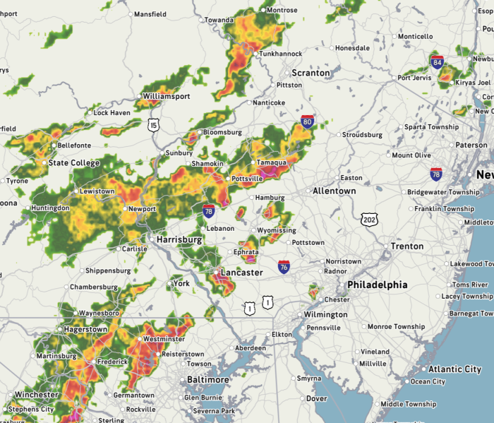
There's definitely activity out there that looks pretty extreme in spots. It's tracking a little NE. Hard to say for sure maybe 6 . . . 7?
jamie said:
There's definitely activity out there that looks pretty extreme in spots. It's tracking a little NE. Hard to say for sure maybe 6 . . . 7?
you didn’t just do that
BULLETIN - IMMEDIATE BROADCAST REQUESTED
Severe Thunderstorm Warning
National Weather Service New York NY
607 PM EDT Wed May 20 2026

The National Weather Service in Upton NY has issued a

* Severe Thunderstorm Warning for...
  Hudson County in northeastern New Jersey...
  Union County in northeastern New Jersey...
  Southern Essex County in northeastern New Jersey...
  Richmond County in southeastern New York...
  Kings County in southeastern New York...
  New York (Manhattan) County in southeastern New York...

* Until 700 PM EDT.

* At 607 PM EDT, severe thunderstorms were located along a line
  extending from near Peapack And Gladstone to Somerset to near
  Plainsboro Center, moving east at 35 mph.

  HAZARD...60 mph wind gusts and penny size hail.

  SOURCE...Radar indicated.

  IMPACT...Expect damage to trees and power lines.

* Severe thunderstorms will be near...
  Plainfield around 620 PM EDT.
  Summit and Tottenville around 630 PM EDT.
  Linden and Millburn around 635 PM EDT.
  Elizabeth and Todt Hill around 640 PM EDT.
  Port Richmond around 645 PM EDT.
  Newark and Bayonne around 650 PM EDT.
  Coney Island and Bay Ridge around 655 PM EDT.

PRECAUTIONARY/PREPAREDNESS ACTIONS...

For your protection move to an interior room on the lowest floor of a
building.


yahooyahoo said:
That was a bust (in our immediate area).
We just caught the edge of it -- there was some notable wind damage south of us
Some crazy videos coming out of NYC from yesterday. Certain parts of the city had serious flooding.
Friday afternoon, May 22
I hate to be the bearer of bad news, but I'm not going to lie to you...it is likely to rain all weekend
A few showers are possible this evening after 7pm. Today's high of 65 is the warmest it's likely to be between now and Monday. Low tonight around 50
Tonight into Saturday showers move in in the wee hours, more likely a steady rain after 11 Saturday morning, light to moderate, and breezy. high and low in the mid 50s, rain a bit heavier overnight
Sunday, you guessed it, rain likely, breezy, high low 60s. By the afternoon only showers likely, but they could be heavy at times, and can't rule out a bit of thunder. Same for Sunday night, lows in the mid 50s
While Memorial Day could start off with showers, it should taper off to just cloudy by mid morning. High mid 70s

Monday, May 25th
The rain is over!
This afternoon, mixed sun and clouds (more clouds than sun, I'm afraid) high low 70s
Tonight, mostly cloudy, low around 60
Tuesday more sun, high around 80, overnight low mid 60s
Wed partly sunny and warm, high could reach the mid 80s. A cold front moves through Wed night, could trigger a shower or two and a non-zero chance of thunder, low mid 60s
Thursday and Friday looking good with ample sun and highs in the upper 70s, lows overnight in the upper 50s
Early for a weekend forecast, but it looks promising, sunny and highs around 70
Monday June First
Seasonably warm and probably dry
Today starts out sunny and warm and mostly sunny, chance of showers in the afternoon, high mid 70s, low overnight low 50s
Tuesday clear, high upper 70s, low around 60
Wednesday sunny and a bit warmer, we should see highs in the low 80s, low around 60
Low humidity will make it even more pleasant for the first part of the week
End of week warmer, with highs Thurs - Saturday near 90 and overnight lows near 70
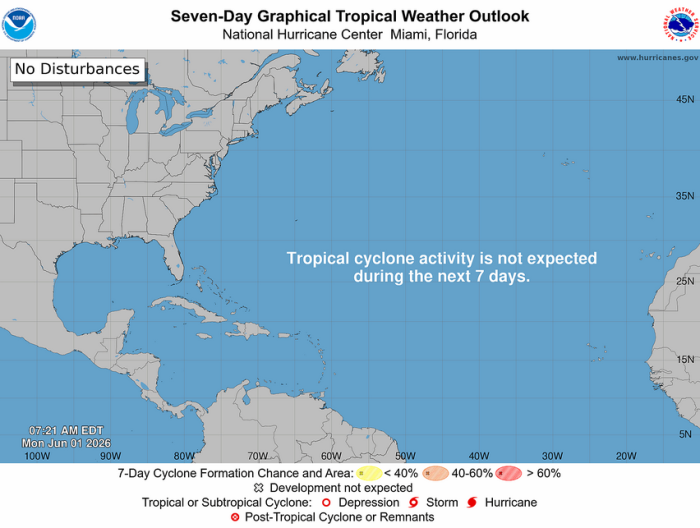
Also, happy first day of Atlantic Hurricane season! The seas are calm today.
Rentals

Sponsored Business


Promote your business here - Businesses get highlighted throughout the site and you can add a deal.

Monday, May 18
Heat wave continues through midweek
Today, sunny, high lower 90s, overnight low lower 70s
Tuesday, a few clouds and an afternoon breeze, high upper 90s, low upper 70s
Wednesday, high mid 90s then afternoon showers, slight chance of thunder and lightning as the weather breaks and a cold front moves through dropping temperatures to an overnight low in the upper 50s
Thursday more seasonal weather returns with mixed sun and clouds and a high in the lower 70s, low in the mid 50s
The weekend is looking seasonal and mixed, with some sun, but mostly cloudy, chance of a few showers (maybe even a thunderstorm Saturday afternoon), highs in the mid 60s
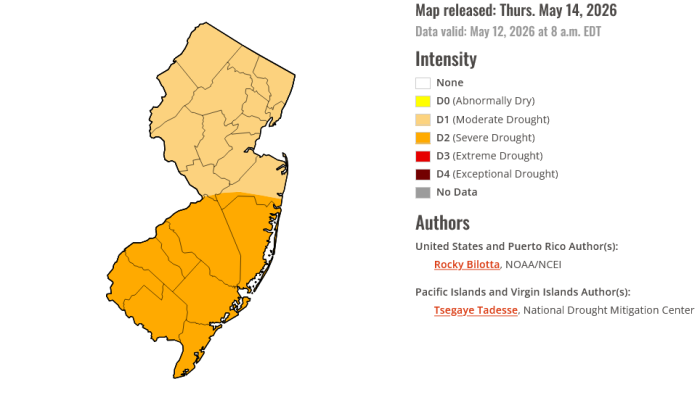
Please remember that we are still in drought conditions and be mindful of fire and open flame both in our yards and in the parks and woods.