Warnings and Watches have ended for Monday, April 13th


Tomorrow's (Monday April 13 2020) High Wind Watch was just upgraded to a HIGH WIND WARNING.
This action indicates a high degree of certainty by the national weather service that the forecasted winds of 25 - 35mph with gusts up to 60mph will occur.
In addition, heavy rain is expected, with total rainfall of 1 - 2.5 inches between midnight tonight and midnight tomorrow. Thunderstorms are likely, with heavier rain and higher gusting more likely during the storms.
From the NWS:
URGENT - WEATHER MESSAGE
National Weather Service New York NY
354 PM EDT Sun Apr 12 2020
CTZ005-006-NJZ004-006-103>108-NYZ069-070-130830-
/O.UPG.KOKX.HW.A.0001.200413T1000Z-200413T2200Z/
/O.NEW.KOKX.HW.W.0002.200413T1000Z-200413T2200Z/
Northern Fairfield-Northern New Haven-Eastern Passaic-Hudson-
Western Bergen-Eastern Bergen-Western Essex-Eastern Essex-
Western Union-Eastern Union-Rockland-Northern Westchester-
354 PM EDT Sun Apr 12 2020
...HIGH WIND WARNING IN EFFECT FROM 6 AM TO 6 PM EDT MONDAY...
* WHAT...South winds 25 to 35 mph with gusts up to 60 mph
expected.
* WHERE...Portions of northeast New Jersey, southern Connecticut
and southeast New York.
* WHEN...From 6 AM to 6 PM EDT Monday.
* IMPACTS...Damaging winds will blow down trees and power lines.
Even sturdy and well secured tent structures could be damaged.
Widespread power outages are expected. Travel will be difficult,
especially for high profile vehicles.
PRECAUTIONARY/PREPAREDNESS ACTIONS...
People should avoid being outside in forested areas and around
trees and branches. If possible, remain in the lower levels of
your home during the windstorm, and avoid windows. Use caution if
you must drive.


I heard up to 70mph winds? Possible hail, tornado? Sound like a mini hurricane.

Jaytee said:
I heard up to 70mph winds? Possible hail, tornado? Sound like a mini hurricane.
70 mph winds are much more likely out on Long Island than here.
Here is the tornado outlook for tomorrow. As you can see, there is little likelihood of a tornado in northern New Jersey.

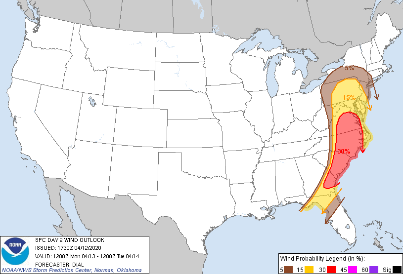
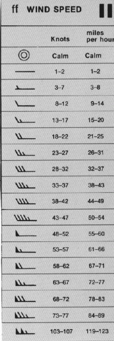
Here is the wind speed outlook. As you can see, gusts of 60 mph (50 knots = 58 mph) are more likely, 5% probability. Hence the warning.
Hail is possible in any thunderstorm. Tomorrow's storm may have small hail, but the probability for really damaging hail is low.

max_weisenfeld said:
Here is the wind speed outlook. As you can see, gusts of 60 mph (50 knots = 58 mph) are more likely, 5% probability. Hence the warning.
This graphic is from the SPC for severe-level wind speeds in thunderstorms, right? Correct me if I’m wrong, but gusts outside of thunderstorms would not be included, right? If they were, then risk in LI/CT, SE Mass should be higher.
ETA: thank you for all of your weather posts and keeping everyone informed! They’re invaluable for the community and I love reading through them every time.
WindyT said:
max_weisenfeld said:
Here is the wind speed outlook. As you can see, gusts of 60 mph (50 knots = 58 mph) are more likely, 5% probability. Hence the warning.
This graphic is from the SPC for severe-level wind speeds in thunderstorms, right? Correct me if I’m wrong, but gusts outside of thunderstorms would not be included, right? If they were, then risk in LI/CT, SE Mass should be higher.
ETA: thank you for all of your weather posts and keeping everyone informed! They’re invaluable for the community and I love reading through them every time.
You're correct. The main threat with this system to our area is gusts within thunderstorms, so in this case I think the spc is a good guide to risk. Also note the spc is about severe thunderstorms, which are not inclusive of the majority of storms we see but are the biggest risk.
Monday morning April 13 update.
There is a HIGH WIND WARNING until 6 pm this evening. Steady winds off 25 - 35 mph with gusts of 60 mph possible.
The main risk today is gusty winds in small but strong thunderstorms embedded in front of and into a warm front that will pass through the are late this morning through early afternoon. Heavy rain can also occur in these storms. Expect 1 - 2 inches of rain overall.
The likelihood of thunderstorms in the area with this system is almost 100%. The likelihood of 25 -35 mph winds is also very high. The likelihood of 1 - 2 inches of rain, also very high.
The higher gusts depend on where the individual thunderstorm cells set up, and this is harder to forecast more than 30 - 60 minutes in advance.
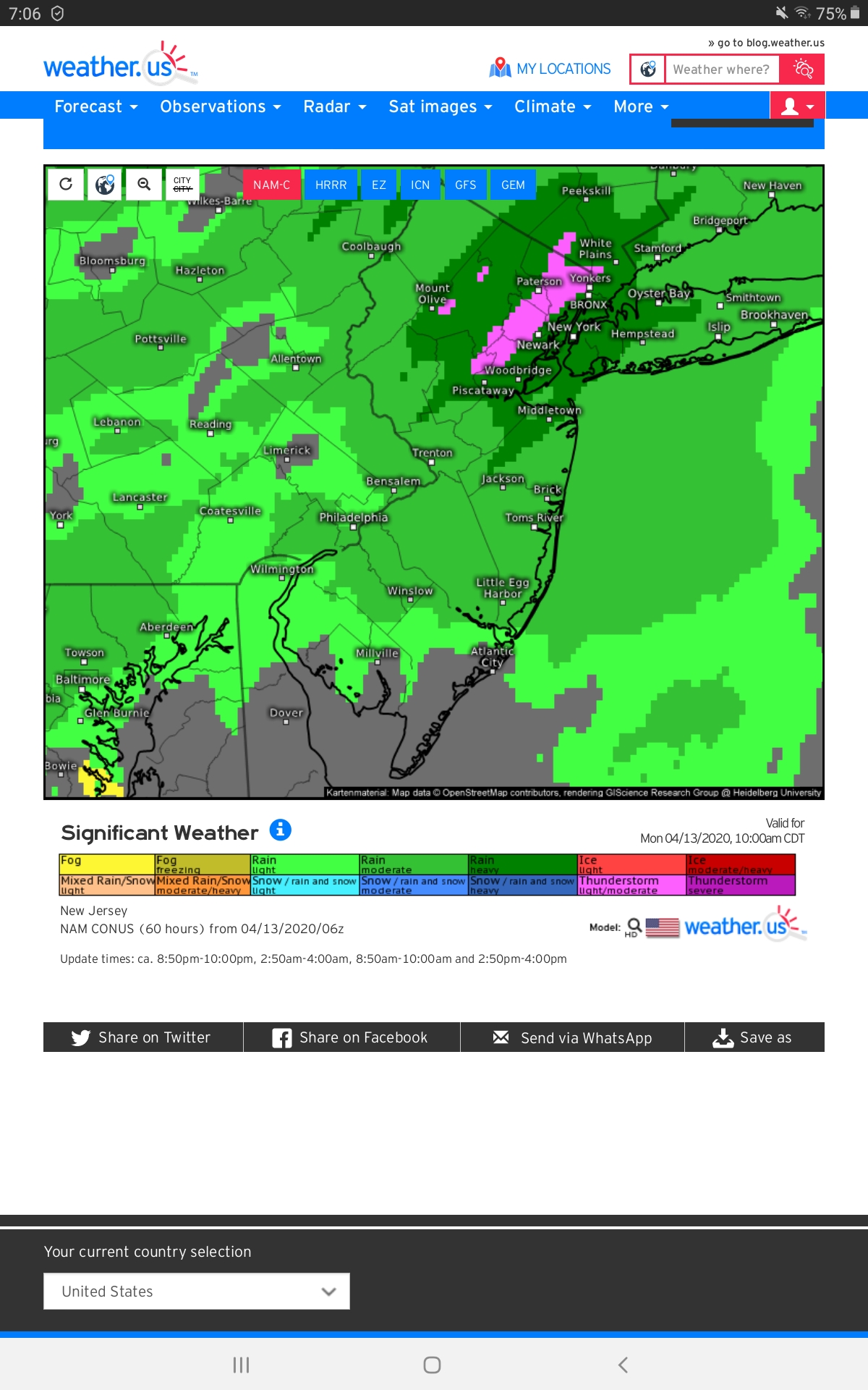
Image below shows possible thunderstorm activity between 9 and 11 this morning on one of the models.
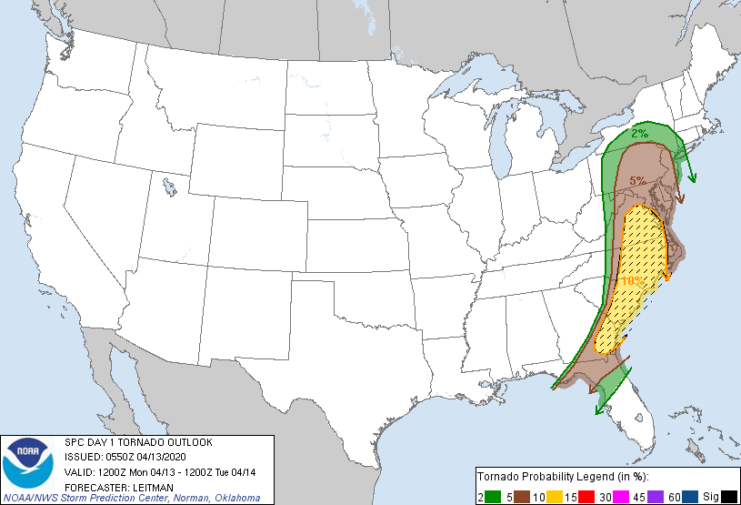


A tornado watch has been issued for the majority of NJ. Maplewood is Not included in this watch, however severe weather remains possible.


bub said:
Not complaining but where's the wind?
Here's some, outside my house in S.O. Huge gust earlier took a healthy branch down right into our rear window. Anyone know a good mobile auto-glass place that might be open?


guitardad said:
Here's some, outside my house in S.O. Huge gust earlier took a healthy branch down right into our rear window. Anyone know a good mobile auto-glass place that might be open?
Oh that sucks.
Your auto insurer might be able to connect you with someone.
mrincredible said:
Oh that sucks.
Your auto insurer might be able to connect you with someone.
Thanks. yes, I was happily surprised that some places were open and can take our car in tomorrow. All set with insurance too. 

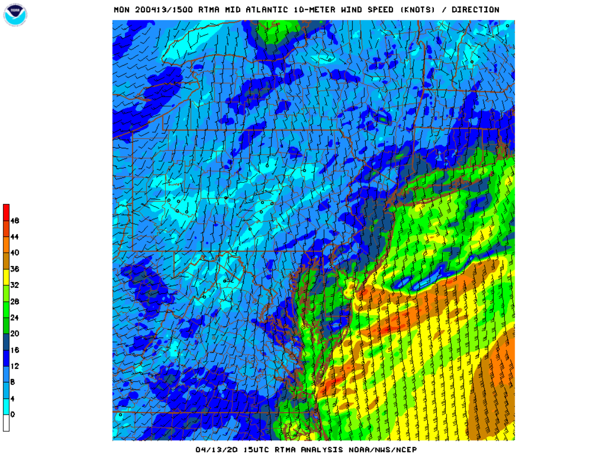
The national weather service has lifted the high wind warning in effect since this morning.
The forecast was for steady 25 - 35 mph winds. We had steady 20 mph winds for most of the morning and also a couple of hours this afternoon. The higher forecast was contingent on thunderstorms. Thunderstorms throughout the region dropped hail and high winds. Luckily MAPSO was spared the 50 - 70 mph winds that were reported elsewhere, especially to our south, over Long Island, and in New England.
There must have been a lot of local variation because I don't think we got anything close to 20 mph. Not even momentary gusts. Sorry about the damage.

I just hooked my rainwater tanks back up yesterday and filled about 1200 gallons today. Lots of rain.

Branches and twigs strewn across my lawn suggest that we did get strong winds by me.
joan_crystal said:
Branches and twigs strewn across my lawn suggest that we did get strong winds by me.
Same same.


The NWS has posted a High Wind Watch for Monday, April 13th, from 6:00am until 6:00 pm.
Steady winds of 20 - 30mph with gusts as high as 60mph are expected during the day Monday along with showers and a possible thunderstorm in the morning. Rain could be heavy at times, especially if we do get a thunderstorm.
~~~~~~~~~~
From the NWS:
URGENT - WEATHER MESSAGE
National Weather Service New York NY
412 PM EDT Sat Apr 11 2020
CTZ005-006-NJZ002-004-103-105-107-NYZ067>070-120900-
/O.NEW.KOKX.HW.A.0001.200413T1000Z-200413T2200Z/
Northern Fairfield-Northern New Haven-Western Passaic-
Eastern Passaic-Western Bergen-Western Essex-Western Union-Orange-
Putnam-Rockland-Northern Westchester-
412 PM EDT Sat Apr 11 2020
...HIGH WIND WATCH IN EFFECT FROM MONDAY MORNING THROUGH MONDAY AFTERNOON...
* WHAT...South winds 20 to 30 mph with gusts up to 60 mph possible.
* WHERE...Interior portions of northeast New Jersey, southwest
Connecticut, and southeast New York, roughly west and north of the
Garden State Parkway, Interstate 287, the Merritt Parkway, and
Interstate 91.
* WHEN...From Monday morning through Monday afternoon.
* IMPACTS...Damaging winds could blow down trees and power lines.
Widespread power outages are possible. Travel could be difficult,
especially for high profile vehicles.
* ADDITIONAL DETAILS...Highest winds expected in the higher elevations and in exposed areas such as along the Hudson River.
PRECAUTIONARY/PREPAREDNESS ACTIONS...
Monitor the latest forecasts and warnings for updates on this situation. Fasten
loose objects or shelter objects in a safe location prior to the onset
of winds.