Wind Advisory Remains in Effect Today, Sat 3/3

This sounds like a good way to wash away the residual winter salt.


Ugh! Sounds like a good day to stay home...
eta: But thank you, max!


marylago said:
Ugh! Sounds like a good day to stay home...
eta: But thank you, max!
Absolutely! A fuzzy slipper day.

Someone tell the man in charge that we've had plenty of rain so far thank you very much. I will now have a front lawn swamp for the next week at least. yuk.

I don't see the township clearing the grates to the storm drains that are currently full of debris and really not ready for the storm we are about to have. I do the ones on my street, but it is a town-wide problem.

or everyone could each just rake out the nearest drain and clear like you have and the issue would be solved. Funny enough, I just did the one down the hill from our house earlier today thinking about the impending rain forecast.

dr_matt said:
I don't see the township clearing the grates to the storm drains that are currently full of debris and really not ready for the storm we are about to have. I do the ones on my street, but it is a town-wide problem.
They did my street (in Maplewood) earlier this week.
With the afternoon update, the war of forecasts between the weenies who are sure this is a snowstorm and the calmer heads at the National Weather Service continues. At least in the minds of the weenies. I think the NWS is ignoring them.
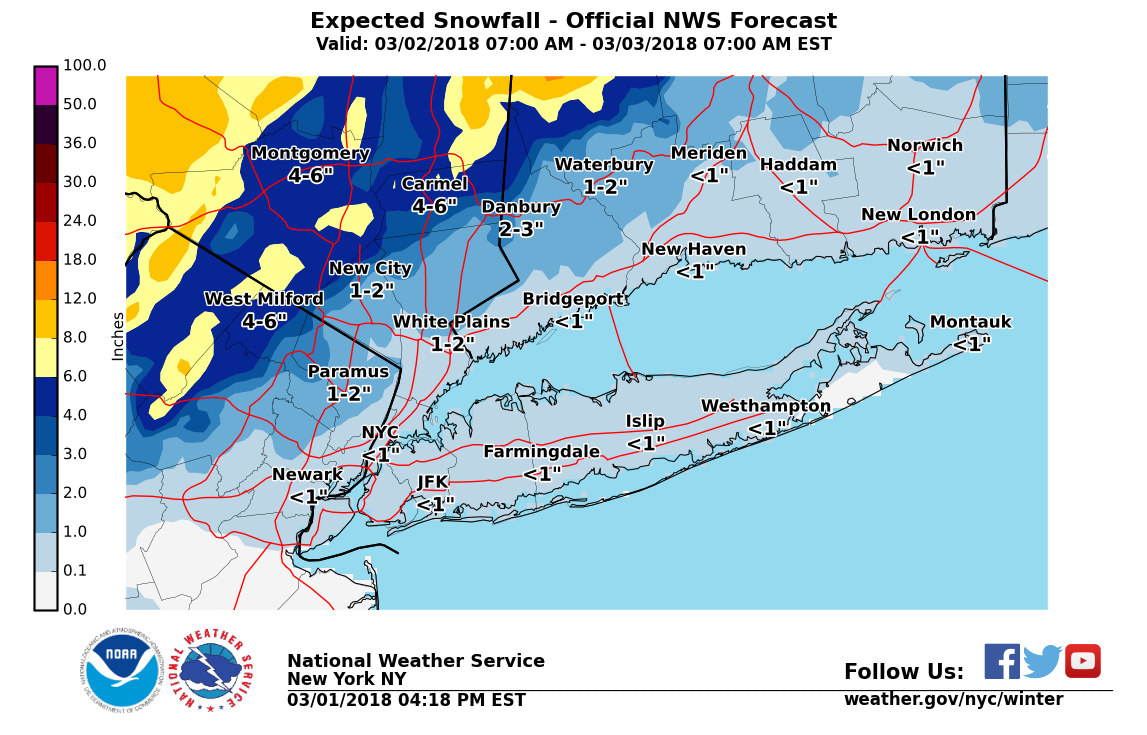
There is good model consensus for the track of this storm. It is a slow-moving, single low crossing the area from west to east. Timing remains the same, with rain moving in this evening, possibly mixing with snow tomorrow during the day and continuing into Saturday. Little or no accumulation of snow in MAPSO, but there are winter storm warnings up west and north of us, and there is likely to be more snow at higher elevations. This is one where being in Newstead (or Morristown) might make a bit of a difference, but still it is mostly a possible 1" accumulation here. Note that, as the snow is falling conditions could get dangerous, even if the snow is then washed away by the rain.
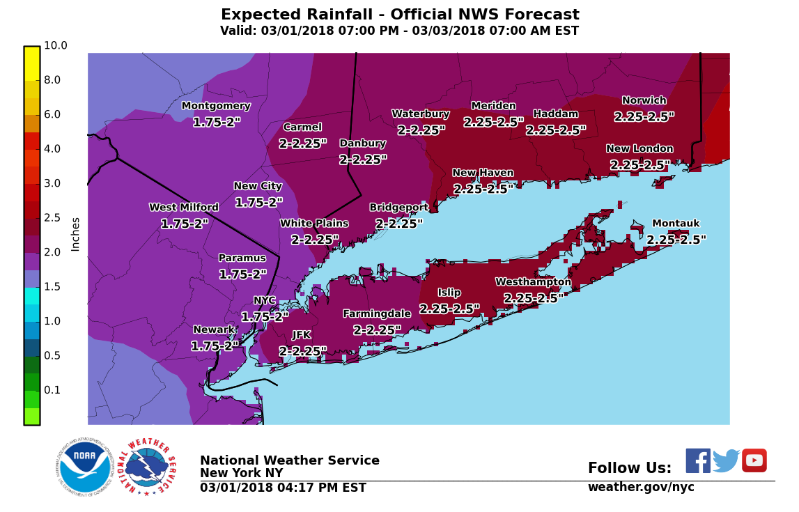
Rain will be heavy at times. The total rainfall, likely to be around two inches, is spread out over 36 hours, so flooding, although possible, is not likely. However, that is still a lot of water on saturated ground so the NWS has issued a Flood Watch for our area.
Wind forecast continues to be in the 20 - 30 range Friday afternoon and night with possible gusts to 50 Friday afternoon, so the NWS has upgraded the watch to an advisory (see below).
Wind Advisory
URGENT - WEATHER MESSAGE
National Weather Service New York NY
317 PM EST Thu Mar 1 2018
CTZ006-007-NJZ004-006-103>108-NYZ069-070-021000-
/O.UPG.KOKX.HW.A.0001.180302T1200Z-180303T1100Z/
/O.NEW.KOKX.WI.Y.0001.180302T1600Z-180303T1100Z/
Northern New Haven-Northern Middlesex-Eastern Passaic-Hudson-
Western Bergen-Eastern Bergen-Western Essex-Eastern Essex-
Western Union-Eastern Union-Rockland-Northern Westchester-
317 PM EST Thu Mar 1 2018
...WIND ADVISORY IN EFFECT FROM 11 AM FRIDAY TO 6 AM EST
SATURDAY...
The National Weather Service in Upton has issued a Wind Advisory,
which is in effect from 11 AM Friday to 6 AM EST Saturday. The
High Wind Watch is no longer in effect.
* WINDS...North 20 to 30 mph with gusts up to 55 mph.
* TIMING...Strongest winds from Friday afternoon through Friday  night.
* IMPACTS...Strong winds may blow down limbs, trees, and power  lines. Scattered power outages are expected. Limited  visibilities will make travel difficult.
PRECAUTIONARY/PREPAREDNESS ACTIONS...
A Wind Advisory is issued when sustained winds of 31 to 39 mph,
or gusts of 46 to 57 mph, are expected or occurring. Winds this
strong can make driving difficult, especially for high profile
vehicles, in open areas, and on elevated roads and bridges. Use
extra caution.
&&
$$
Flood Watch
Flood Watch
National Weather Service New York NY
326 PM EST Thu Mar 1 2018
CTZ005>012-NJZ004-006-103>108-NYZ068>075-078>081-176>179-021000-
/O.CON.KOKX.FA.A.0003.180302T1100Z-180303T1100Z/
/00000.0.ER.000000T0000Z.000000T0000Z.000000T0000Z.OO/
Northern Fairfield-Northern New Haven-Northern Middlesex-
Northern New London-Southern Fairfield-Southern New Haven-
Southern Middlesex-Southern New London-Eastern Passaic-Hudson-
Western Bergen-Eastern Bergen-Western Essex-Eastern Essex-
Western Union-Eastern Union-Putnam-Rockland-Northern Westchester-
Southern Westchester-New York (Manhattan)-Bronx-
Richmond (Staten Island)-Kings (Brooklyn)-Northwestern Suffolk-
Northeastern Suffolk-Southwestern Suffolk-Southeastern Suffolk-
Northern Queens-Northern Nassau-Southern Queens-Southern Nassau-
326 PM EST Thu Mar 1 2018
...FLOOD WATCH REMAINS IN EFFECT FROM FRIDAY MORNING THROUGH LATE
FRIDAY NIGHT...
The Flood Watch continues for
* Portions of southern Connecticut, northeast New Jersey, and  southeast New York, including the following areas, in southern  Connecticut, Northern Fairfield, Northern Middlesex, Northern  New Haven, Northern New London, Southern Fairfield, Southern  Middlesex, Southern New Haven, and Southern New London. In  northeast New Jersey, Eastern Bergen, Eastern Essex, Eastern  Passaic, Eastern Union, Hudson, Western Bergen, Western Essex,  and Western Union. In southeast New York, Bronx, Kings  (Brooklyn), New York (Manhattan), Northeastern Suffolk,  Northern Nassau, Northern Queens, Northern Westchester,  Northwestern Suffolk, Putnam, Richmond (Staten Island),  Rockland, Southeastern Suffolk, Southern Nassau, Southern  Queens, Southern Westchester, and Southwestern Suffolk.
* From Friday morning through late Friday night
* A deepening coastal low late tonight into Friday will bring  heavy rain across the area, with the potential for 2 to 3 inches  of rainfall. Heavier bands could produce localized higher  amounts.
* Smaller rivers and streams across the area will be most  vulnerable to the possibility of flooding. In addition, poor  drainage urban flooding is possible and may be enhanced by the  effects of coastal flooding.
PRECAUTIONARY/PREPAREDNESS ACTIONS...
A Flood Watch means there is a potential for flooding based on
current forecasts. You should monitor later forecasts and be
alert for possible flood warnings. Those living in areas prone to
flooding should be prepared to take action should flooding
develop.


Thanks Max, as always!
I'm scheduled to be driving to an event in Sussex county tomorrow afternoon/evening - not far from Allamuchy, out I-80. Any advice about timing? Hoping it won't be TOO bad. (Once there we will be indoors, and staying over until late Saturday, so it's the getting there that is the issue.)
sac said:
Thanks Max, as always!
I'm scheduled to be driving to an event in Sussex county tomorrow afternoon/evening - not far from Allamuchy, out I-80. Any advice about timing? Hoping it won't be TOO bad. (Once there we will be indoors, and staying over until late Saturday, so it's the getting there that is the issue.)
Earlier is better
Rain has crossed from PA into NJ in the last half hour.
Here are the NWS forecast graphics:

Oy I have a fight outta EWR AT 4pm. Looks like I may be spending Shabbat at the airport
I hooked my rainwater collection system back up. Let's see how much I get.


dr_matt said:
I don't see the township clearing the grates to the storm drains that are currently full of debris and really not ready for the storm we are about to have. I do the ones on my street, but it is a town-wide problem.
I raked the one by my house this morning. Not that hard to do.


Hi Max. College student plans to drive to W. Orange from Saratoga Springs tomorrow to attend a show Sat. night. When would you advise she hit the road? About 2 hrs will be straight down the NY Thruway.
Thanks!
The earlier the better.
It is going to be snowing in the southern Catskills from early morning.

hmm, I’m Friday and Saturday night in Asbury Park at an event... I guess it’s far better there than in Sea Girt say in terms of flooding
4 PM flight was canceled as expected. Got on the 6 AM one. Hope we get out
Updated headline advisories from the NWS:
Flood Advisory
National Weather Service New York NY
457 AM EST FRI MAR 2 2018
NJC003-013-017-031-039-NYC005-047-059-061-081-085-087-119-021400-
/O.CON.KOKX.FA.Y.0011.000000T0000Z-180302T1400Z/
/00000.N.ER.000000T0000Z.000000T0000Z.000000T0000Z.OO/
Hudson NJ-Passaic NJ-Union NJ-Bergen NJ-Essex NJ-Queens NY-
Richmond NY-Bronx NY-Kings NY-Rockland NY-Westchester NY-
New York (Manhattan) NY-Nassau NY-
457 AM EST FRI MAR 2 2018
...THE URBAN AND SMALL STREAM FLOOD ADVISORY REMAINS IN EFFECT UNTIL
900 AM EST FOR HUDSON...EASTERN PASSAIC...UNION...BERGEN...ESSEX...
QUEENS...RICHMOND...BRONX...KINGS...ROCKLAND...WESTCHESTER...NEW YORK
(MANHATTAN) AND NASSAU COUNTIES...
At 435 AM EST, National Weather Service Doppler Radars indicated
moderate rain continues across the region. Generally, an inch of
rain has fallen since the rain began last evening with up to 1.5
inches having occurred in portions of New York City.
Minor flooding is occurring on some flood prone roadways. Expect
some lane and even some roadway closures in flood prone areas to
occur through the morning rush - plan according.
PRECAUTIONARY/PREPAREDNESS ACTIONS...
Turn around, don`t drown when encountering flooded roads. Most flood
deaths occur in vehicles.
Be especially cautious at night when it is harder to recognize the
dangers of flooding.
&&
LAT...LON 4060 7422 4060 7446 4076 7436 4091 7433
4090 7427 4099 7430 4115 7423 4132 7398
4137 7355 4121 7348 4110 7373 4098 7365
4091 7375 4085 7376 4087 7347 4061 7342
4054 7395 4060 7404 4050 7422 4050 7426
$$
Flood Watch
Flood Watch
National Weather Service New York NY
339 AM EST Fri Mar 2 2018
CTZ005>012-NJZ004-006-103>108-NYZ068>075-078>081-176>179-022145-
/O.CON.KOKX.FA.A.0003.180302T1100Z-180303T1100Z/
/00000.0.ER.000000T0000Z.000000T0000Z.000000T0000Z.OO/
Northern Fairfield-Northern New Haven-Northern Middlesex-
Northern New London-Southern Fairfield-Southern New Haven-
Southern Middlesex-Southern New London-Eastern Passaic-Hudson-
Western Bergen-Eastern Bergen-Western Essex-Eastern Essex-
Western Union-Eastern Union-Putnam-Rockland-Northern Westchester-
Southern Westchester-New York (Manhattan)-Bronx-
Richmond (Staten Island)-Kings (Brooklyn)-Northwestern Suffolk-
Northeastern Suffolk-Southwestern Suffolk-Southeastern Suffolk-
Northern Queens-Northern Nassau-Southern Queens-Southern Nassau-
339 AM EST Fri Mar 2 2018
...FLOOD WATCH REMAINS IN EFFECT THROUGH LATE TONIGHT...
The Flood Watch continues for
* Portions of southern Connecticut, northeast New Jersey, and
southeast New York, including the following areas, in southern
Connecticut, Northern Fairfield, Northern Middlesex, Northern
New Haven, Northern New London, Southern Fairfield, Southern
Middlesex, Southern New Haven, and Southern New London. In
northeast New Jersey, Eastern Bergen, Eastern Essex, Eastern
Passaic, Eastern Union, Hudson, Western Bergen, Western Essex,
and Western Union. In southeast New York, Bronx, Kings
(Brooklyn), New York (Manhattan), Northeastern Suffolk,
Northern Nassau, Northern Queens, Northern Westchester,
Northwestern Suffolk, Putnam, Richmond (Staten Island),
Rockland, Southeastern Suffolk, Southern Nassau, Southern
Queens, Southern Westchester, and Southwestern Suffolk.
* Through late tonight
* A deep coastal will continue to produce heavy rain across the
area, with the potential for 2 to 4 inches of total rainfall.
Heavier bands could produce localized higher amounts.
* Smaller rivers and streams across the area will be most
vulnerable to the possibility of flooding. In addition, poor
drainage urban flooding will continue across the area, and may
be enhanced by the effects of coastal flooding.
PRECAUTIONARY/PREPAREDNESS ACTIONS...
A Flood Watch means there is a potential for flooding based on
current forecasts. You should monitor later forecasts and be
alert for possible flood warnings. Those living in areas prone to
flooding should be prepared to take action should flooding
develop.
&&
$$
JMC
Hazardous Weather Outlook
Hazardous Weather Outlook
National Weather Service New York NY
336 AM EST Fri Mar 2 2018
CTZ006>008-NJZ004-103>105-107-NYZ069-070-030845-
Northern New Haven-Northern Middlesex-Northern New London-
Eastern Passaic-Western Bergen-Eastern Bergen-Western Essex-
Western Union-Rockland-Northern Westchester-
336 AM EST Fri Mar 2 2018
...HIGH WIND WARNING IN EFFECT UNTIL 6 AM EST SATURDAY...
...FLOOD WATCH IN EFFECT THROUGH LATE TONIGHT...
This Hazardous Weather Outlook is for southern Connecticut,
northeast New Jersey and southeast New York.
.DAY ONE...Today and Tonight.
Please listen to NOAA Weather Radio or go to weather.gov on the
Internet for more information about the following hazards.
High Wind Warning.
Flood Watch.
.DAYS TWO THROUGH SEVEN...SATURDAY THROUGH THURSDAY.
No hazardous weather is expected at this time.
.SPOTTER INFORMATION STATEMENT...
Weather spotters are encouraged to report significant weather
conditions according to Standard Operating Procedures.
&&
This Hazardous Weather Outlook provides a summary of potential
widespread hazardous weather events that may reach NWS warning
criteria. Most long fused NWS watches...warnings and advisories in
effect are highlighted.
Please refer to the latest NWS forecasts for weather not meeting NWS
warning criteria.
$$
High Wind Warning
URGENT - WEATHER MESSAGE
National Weather Service New York NY
333 AM EST Fri Mar 2 2018
CTZ006-007-NJZ004-006-103>108-NYZ069-070-021645-
/O.UPG.KOKX.WI.Y.0001.180302T1600Z-180303T1100Z/
/O.EXB.KOKX.HW.W.0001.180302T1100Z-180303T1100Z/
Northern New Haven-Northern Middlesex-Eastern Passaic-Hudson-
Western Bergen-Eastern Bergen-Western Essex-Eastern Essex-
Western Union-Eastern Union-Rockland-Northern Westchester-
333 AM EST Fri Mar 2 2018
...HIGH WIND WARNING IN EFFECT UNTIL 6 AM EST SATURDAY...
The National Weather Service in Upton has issued a High Wind
Warning, which is in effect until 6 AM EST Saturday. The Wind
Advisory is no longer in effect.
* WINDS...North 25 to 35 mph with gusts up to 60 mph.
* TIMING...Strongest winds this afternoon and tonight.
* IMPACTS...Damaging winds will blow down trees and power lines.
Power outages are expected. Travel will be difficult, especially
for high profile vehicles.
PRECAUTIONARY/PREPAREDNESS ACTIONS...
A Wind Advisory is issued when sustained winds of 31 to 39 mph,
or gusts of 46 to 57 mph, are expected or occurring. Winds this
strong can make driving difficult, especially for high profile
vehicles, in open areas, and on elevated roads and bridges. Use
extra caution.
A High Wind Warning means a hazardous high wind event is expected
or occurring. Sustained wind speeds of at least 40 mph or gusts
of 58 mph or more can lead to property damage.
&&
$$
U.S. Dept. of Commerce
NOAA National Weather Service
1325 East West Highway
Silver Spring, MD 20910
E-mail: w-nws.webmaster@noaa.gov
Page last modified: May 16, 2007
Disclaimer
Credits
Glossary
Privacy Policy
About Us
Career Opportunities
NATIONAL WEATHER SERVICE: for Safety, for Work, for Fun - FOR LIFE
What that meanns is:
Heavy rains today can cause small stream and urban flooding.
High winds are expedted this afternoon, steady winds of 25 -35 mph with gusts up to 60
Snow is not out of the question later today, most likely as a mix of wet snow and rain is the heavier precipitation bands. Still do not expect much accumulation here but likely to effect driving while it is happening. Note that around us, especially to the north and west, it is snowing heavily, with significant accumulations.


I’m out in Western Morris county and they are using our last snow day today. Should be changing over to snow shortly.
And now it has

When I walked out the door at 6 AM in Morristown it was raining but the temperature was falling and it felt (and smelled) like it might flip to mixed precipitation. But by the time I got to the train station at 6:15 it was still all rain.
blackcat said:
I’m out in Western Morris county and they are using our last snow day today. Should be changing over to snow shortly.
And now it has
Which shows how fine the rain/snow line is in this storm.
Sponsored Business


Promote your business here - Businesses get highlighted throughout the site and you can add a deal.

...and maybe a little snow.
The NWS has issued a Flood Watch and a High Wind Watch for our area tonight and tomorrow.
A significant storm with drifts south of Long Island tonight and tomorrow. Rain, heavy at times, will develop most likely after 6:00 pm tonight, Thursday 3/1, and continue through the night and through the day Friday.
Friday afternoon may see some snow mixing in. Significant accumulation is not expected at this time, but with temps forecast to be at or near freezing, a slight shift could change things.
Rain ends Saturday morning.
Winds rise Friday afternoon. Forecast winds are now in the 20 - 30 mph range with some higher gusts, possibly to 50. If this forecast increases at all, expect the watch to be raised to at least and advisory, as with the saturated ground branches and trees may be at risk. Wind tapers off Saturday morning.
There is still some degree of uncertainty with this system.
ETA it is a Flood Watch, not a "flash flood watch." Potential for small stream flooding and urban ponding.