Winter Weather Advisory Monday 2/22 for 2" - 4" of !@#$%&* Snow
/start grumpy
Between recent hip surgery and some pulmonary issues, I'm not as mobile as I'd like to be. The snows have practically made me a prisoner in my apartment. Walks weren't cleared til Thursday last week. Then on Saturday, there were strategically placed ice patches, and walls of snow by the curb made by brainless snow cleaners, that made me walk around for 15 minutes before I could get to my car, which is less than 100 feet from my front door.
Now I have semi-daily snow spritzes to look forward to.
bleh
/end grumpy
Did someone tell Mother Nature we had a pfft winter last year? Because this really feels like she's making up for lost time.
I blame myself. I have an appointment (for my sister) at Hackensack Medical Center at least once, sometimes more, for the next month or so.
Tues, 2/9 Update
Looks like today's snow will be light, with only likely an inch or so. Should start snowing early, 7:00 or 8:00, and be done by early afternoon.
Thursday's forecast is still uncertain, but trending south, which would spare us most or all the precipitation.
The weekend is a hot mess, with the models disagreeing like family talking politics at Thanksgiving. The NWS is politely throwing their hands up in the air and going with 50/50 chance of snow, maybe on Saturday. We will just have to wait a day or two and see what develops.
oots said:
ok first one down! lets hope they are all like this!
Amen!
max_weisenfeld said:
Tues, 2/9 Update
...The weekend is a hot mess, with the models disagreeing like family talking politics at Thanksgiving. ...


Wed 2/10 update
Today, please be aware this morning if you go out that there are areas of black ice and possibly freezing fog that could make roads, steps, and walks slick and treacherous.
Tomorrow, light snow likely, particularly in the morning. Do not expect significant accumulation.
Sunday still a confused picture, with snow or sleet possible.
This pattern continues into next week, with both the possibility of frozen precipitation every couple of days and the uncertainty as to intensity and track.
Well, I bought a 35lb pail of ice melter yesterday, thus ensuring it won't snow for the next two years. Y'all are welcome.
mulemom said:
Well, I bought a 35lb pail of ice melter yesterday, thus ensuring it won't snow for the next two years. Y'all are welcome.
That's great. Thanks for the help. I must say, though, that this technique has sadly temporary benefits as witnessed by the Toro snowblower Ms. bikefixed made me purchase. It worked great for a season but since then it has snowed anyway. More than once over the past couple of years in fact. 
https://getyarn.io/yarn-clip/7ddb228e-5149-42d4-bab9-e0ade9f16bf9
The Snow is Back in the Forecast!
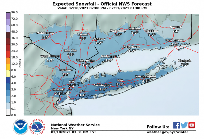
Winter Weather Advisory tonight, 2/10 10pm until tomorrow morning, 2/11 10am.
Bit of a front-end burst of snow tonight, probably from around midnight until 4 or 5am, then light snow until mid-morning. Total snow likely 1" - 3" cold enough that the snow will be light and fluffy. Gets a bit warmer towards afternoon so you might want to shovel right away because then it will freeze and not get above freezing for a couple of days.
From the NWS:Winter Weather Advisory
URGENT - WINTER WEATHER MESSAGENational Weather Service New York NY330 PM EST Wed Feb 10 2021NJZ004-006-103>108Z072>075-078>081-176>179-111000-/O.NEW.KOKX.WW.Y.0005.210211T0300Z-210211T1500Z/Eastern Passaic-Hudson-Western Bergen-Eastern Bergen-Western Essex-Eastern Essex-Western Union-Eastern Union-New York (Manhattan)-Bronx-Richmond (Staten Island)-Kings (Brooklyn)-Northwestern Suffolk-Northeastern Suffolk-Southwestern Suffolk-Southeastern Suffolk-Northern Queens-Northern Nassau-Southern Queens-Southern Nassau-
330 PM EST Wed Feb 10 2021
...WINTER WEATHER ADVISORY IN EFFECT FROM 10 PM THIS EVENING TO 10 AM EST THURSDAY...
* WHAT...Snow expected. Total snow accumulations of 2 to 3 inches.
* WHERE...New York City, Long Island, and most of northeast New Jersey.
* WHEN...From 10 PM this evening to 10 AM EST Thursday.
* IMPACTS...Plan on slippery road conditions. Hazardous conditions will likely impact the morning commute.
PRECAUTIONARY/PREPAREDNESS ACTIONS...Slow down and use caution while traveling. Check local Department of Transportation information services for the latest road conditions.
The ...interesting... weather continues this weekend, Sat 2/12 through Tues 2/15
Current guidance has multiple systems moving through the area with little break between them. Primary periods of precipitation right now would be Sat night through Sunday and again on Monday, with chance of precipitation in between and through Tuesday.
Precipitation type could be snow or sleet, with a low but real possibility of freezing rain. While precipitation will not on the whole be heavy, certain outcomes could produce a few inches of snow. Of course, any freezing rain could also present issues for travel, although at this time a full blown ice storm is unlikely.
max_weisenfeld said:
The ...interesting... weather continues this weekend, Sat 2/12 through Tues 2/15
Current guidance has multiple systems moving through the area with little break between them. Primary periods of precipitation right now would be Sat night through Sunday and again on Monday, with chance of precipitation in between and through Tuesday.
Precipitation type could be snow or sleet, with a low but real possibility of freezing rain. While precipitation will not on the whole be heavy, certain outcomes could produce a few inches of snow. Of course, any freezing rain could also present issues for travel, although at this time a full blown ice storm is unlikely.
Appreciated, Max. Thanks!
We might get freezing rain. Ice storm not ruled out. Hopefully it doesn’t ice up.
Winter Weather Advisory
The NWS has issued a Winter Weather Advisory for the area for this afternoon, Sat 2/12, and tonight.
Periods of snow, sleet, and freezing rain.
While no significant accumulation of ice, and less than an inch of snow/sleet accumulation, are expected travel could still be treacherous during Sat night and Sunday morning.
Conditions likely to repeat Sunday afternoon through Monday, although exact form the precipitation will take is even less certain. Again, even though several waves of weather are passing through, we do not expect an ice storm but rather it is more likely that there will be periods of light snow, sleet, or freezing rain which could produce a thin glaze of ice.
Tempuratures likely to remain at or near freezing for the entire period.
From the NWS:
Winter Weather Advisory
URGENT - WINTER WEATHER MESSAGE
National Weather Service New York NY
318 AM EST Sat Feb 13 2021
NJZ006-105>108-NYZ072>075-078>081-176>179-140900-
/O.NEW.KOKX.WW.Y.0006.210213T1800Z-210214T1500Z/
Hudson-Western Essex-Eastern Essex-Western Union-Eastern Union-
New York (Manhattan)-Bronx-Richmond (Staten Island)-
Kings (Brooklyn)-Northwestern Suffolk-Northeastern Suffolk-
Southwestern Suffolk-Southeastern Suffolk-Northern Queens-
Northern Nassau-Southern Queens-Southern Nassau-
318 AM EST Sat Feb 13 2021
...WINTER WEATHER ADVISORY IN EFFECT FROM 1 PM THIS AFTERNOON TO
10 AM EST SUNDAY...
* WHAT...Mixed precipitation including freezing rain expected.
Total snow accumulations of up to one inch and ice accumulations
of up to one tenth of an inch.
* WHERE...Portions of northeast New Jersey and southeast New
York.
* WHEN...From 1 PM this afternoon to 10 AM EST Sunday.
* IMPACTS...Difficult travel conditions are possible due to icy
roadways, especially this afternoon through tonight
PRECAUTIONARY/PREPAREDNESS ACTIONS...
Slow down and use caution while traveling.
Check local Department of Transportation information services for
the latest road conditions.
&&
A note on NWS products. There are usually three levels of NWS alerts. 'Advisory' is the lowest level, with 'Watch' next and 'Warning' as the most severe. The NWS has criteria for when to deploy what level of alert. They look at what the impacts of the weather are and the likelihood of those impacts. So tonight's Advisory is an alert that there might be slick conditions. With the weather we are looking at, especially for tonight, it is highly unlikely that It will be upgraded to a watch or warning.
Jaytee said:
We might get freezing rain. Ice storm not ruled out. Hopefully it doesn’t ice up.
Ice storm looking a bit more likely
WxNut2.0 said:
Jaytee said:
We might get freezing rain. Ice storm not ruled out. Hopefully it doesn’t ice up.
Ice storm looking a bit more likely
Ugh! Glad I don't have to go anywhere!
I saw someone comment on Facebook about this forecast - not sure if Max's thread or somewhere else - 'At least it isn't snow!' Are they nuts? I'd much rather have snow than other freezing precipitation!
Is it mostly missing us? It doesn't look like much on the current or future prediction radar. But I'm afraid I might be looking at it wrong, or is it expected to be a very 'now-casting' event?
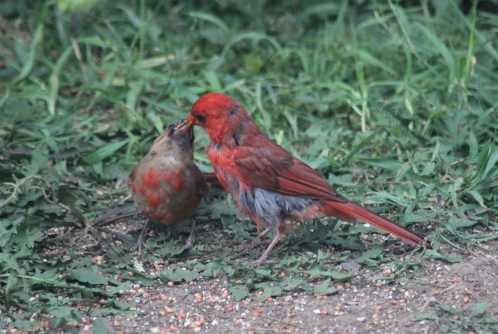
Couple of years ago, I saw a juvenile cardinal begging for food from an adult male. He relented, and fed it on the ground under the feeder.
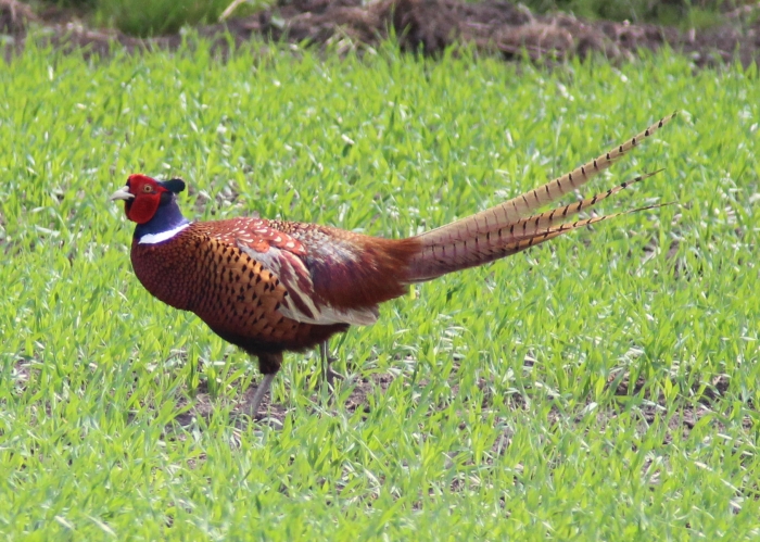
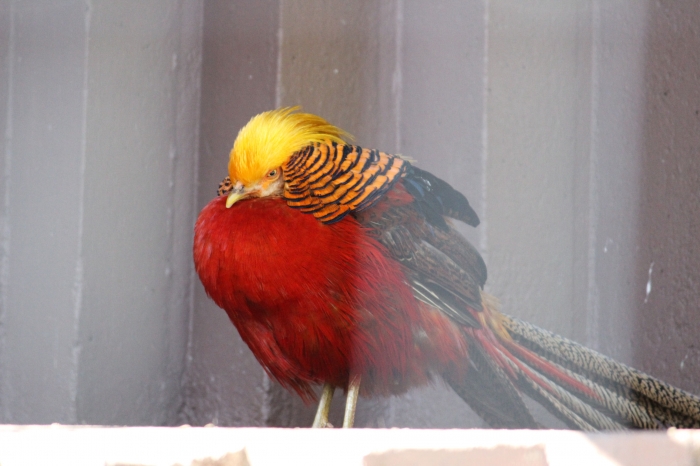
Remaining photos are 'crisper' reds. Ringneck pheasant, golden pheasant (Turtleback Zoo) and red ibis (Central Park Zoo & Bronx Zoo). Lastly a red macaw, seen at an orchid show in Florida.
Happy Valentines Day
Weather continues unstable this week as more weak systems will move through.
Looks like we will get a break today and part of tomorrow. Next low pressure system comes through Monday night through Tuesday morning. Right now, this one could start as snow and either transition to all rain or remain snow/sleet. A short period of heavy precipitation is possible overnight. A period of freezing rain is possible.
Then another day off is likely, and then another precipitation event Wed night through Thursday. Again, the system track will determine whether what falls is snow, sleet, or rain.
None of these systems will be nor'easters. There is a possibility that, like last night's system, they could only be annoyances. But the possibility of a period of freezing rain means we have to pay attention to them.
For Sale
Garage Sales
-
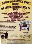
HUGE Rummage sale to benefit the Bloomfield High School Robotics Team Sale Date: Apr 27, 2024
More info
Sponsored Business
Promote your business here - Businesses get highlighted throughout the site and you can add a deal.














Clear and cold today. Snow likely returns Tues with 1" - 3" possible during the day.
Keeping an eye on Thurs where a complicated system is currently modeled to pass close by. As modeled right now we are within the northern edge and would get a few more inches but this one has a lot of moving parts so things could change in either direction.
Unstable pattern appears to continue throughout the next 10 days at least.